There are a ton of places to go riding in and around Tampa. In a single day’s riding, you can ride the downtown network, hop on the Selmon Greenway for a fabulous cruise, or explore the Suncoast Trail.
It might be challenging to decide when there are so many fantastic options available. To help you choose a great place to ride, we’ve chosen some of our local favorites.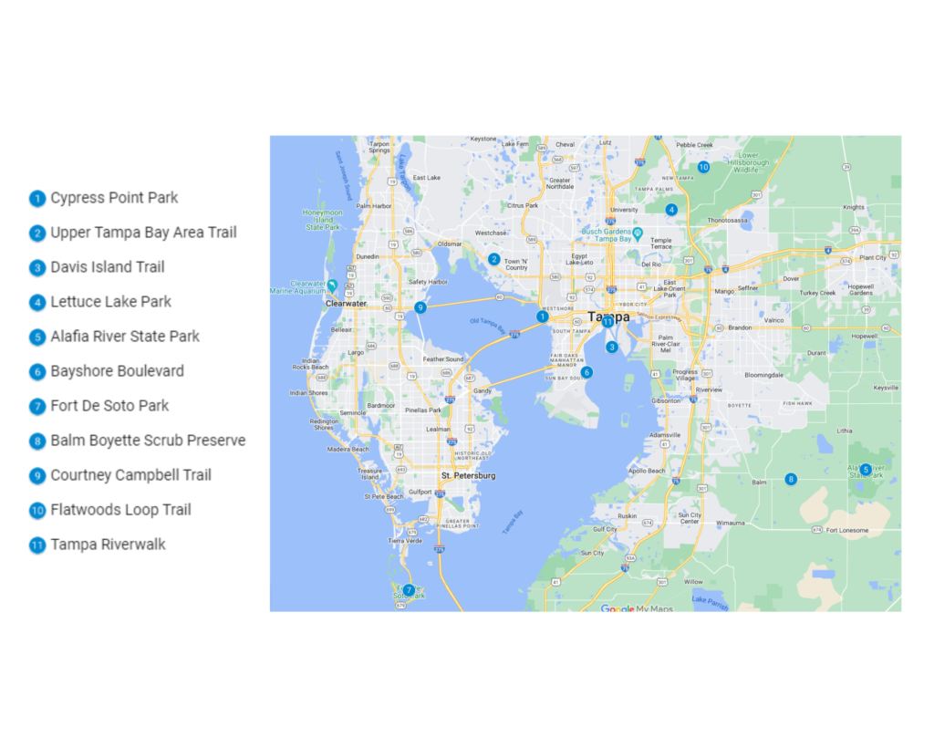
1. Cypress Point Park
The undiscovered jewel of West Tampa, Cypress Point Park, features a lovely beach, a .90-mile asphalt walk, and 44 miles of nature trails. Visitors can enjoy breath-taking sunsets, lovely beach strolls, dunes, beach wildflowers, and fishing opportunities at Cypress Point Park.
Bus stops, plenty of parking, ADA accessibility, bike racks, benches, a boardwalk, a canoe launch, outdoor showers, restrooms, a playground, and picnic pavilions are just a few of the park’s facilities.
Also the Professional Disc Golf Association has listed Cypress Point Park’s 18-hole disc golf course as one of the best 10 free courses in Florida. The 7,980-foot course has concrete tees, varied flora, and features.
| Features | Description |
| Location | Cypress Point Park, West Tampa |
| Length of trail | 1.34 miles |
| Loop, out and back or point to point? | Point to Point |
| Level of difficulty | Easy/Intermediate |
| Terrain | Flat |
| How much is paved | Singletrack |
| Average time to complete | 12 minutes |
| Stop-off points for food, water, restrooms | Yes, portable toilets are available on route |
2. Upper Tampa Bay Area Trail
The Upper Tampa Bay Path is frequently cited as Tampa Bay’s best urban trail, and offers a beautiful diversion from the city’s busy surroundings. The original stretch runs along the west side of the Channel A waterway, a drainage canal, and passes through the suburban Citrus Park on an abandoned train track.
The first mile of the trail from Peterson Park passes grazing sheep, cattle, and other livestock as it travels through a rural setting. At Ehrlich Road, the environment turns increasingly suburban, and enticing nearby restaurants lure you with their menu. Next, you cross the congested Gunn Highway on a magnificent pedestrian bridge, a prime illustration of Florida’s investment in regional trails.
Following a sudden right turn along the Channel A river, which is surrounded by natural flora and stunning cypress trees, the route departs from the original train path. Soon you will cross the serene Rocky Creek on a beautiful wooden bridge.
The Waters Avenue trailhead, which has plenty of parking, restrooms, and an information center, is reached by continuing to follow the west bank. This is an excellent place to start a hike or stop for a rest. To reach the westernmost trailhead, the trail continues beyond Waters Avenue and crosses Memorial Highway.
| Features | Description |
| Location | Upper Tampa Bay Trail |
| Length of trail | 16.5 miles |
| Loop, out and back or point to point? | Point to Point |
| Level of difficulty | Easy/Intermediate |
| Terrain | Flat |
| How much is paved | Singletrack |
| Average time to complete | 3 hours 14 minutes |
| Stop-off points for food, water, restrooms | No |
3. Davis Island Trail
This easily paved trail travels through the Davis Islands’ southern region. A small airport and a beautiful neighborhood with walkable and bikeable streets surround the trail. At Seaplane Basin Park, where there are numerous spots to sit and enjoy views of Hillsborough Bay, there is free parking for the route. The park is accessible from dawn to dusk.
The modest partially paved parking area off Severn Avenue near the trail’s southern end has two places marked as accessible. Asphalt trail surfaces are usually smooth and at least 6 feet wide. Some of the route’s length has a painted center lane line that somewhat narrows it.
A modest (3% or less) slope is expected. Most trail users pushing strollers or using mobility aids should be able to navigate this trail. For extra relaxation, benches are placed along the path.
| Features | Description |
| Location | Davis Island, Florida |
| Length of trail | 4.2 km |
| Loop, out and back or point to point? | Point to Point |
| Level of difficulty | Easy/Intermediate |
| Terrain | 7m Up & 7m Down |
| How much is paved | Singletrack |
| Average time to complete | 45 min |
| Stop-off points for food, water, restrooms | No |
4. Lettuce Lake Park
This wonderful, secluded natural region is home to unique species, including alligators, rabbits, snakes, and a vast variety of waterfowl. There are a few exercise stations throughout the main loop of this short, simple route, including pull-up bars, rings, dip bars, and others. Likewise, canoeing and kayaking are popular activities on this lake.
On-leash dogs are permitted on the other routes; however, bikes and dogs are prohibited on the boardwalk part. By the south end of the walk, there are at least 2 places in the paved parking lots off Lettuce Lake Parkway that are specifically labeled as accessible.
They both have striped access aisles and are accessible by van. Wooden boardwalks or pavement make up the trail’s surface (with railings). Usually, it is at least five feet wide (with many more expansive passing spaces).
The trail’s entire length has a flat gradient (1% or less). The majority of those using wheelchairs, mobility devices, or strollers should be able to navigate this course. Along the path, there are benches and picnic tables for resting.
| Features | Description |
| Location | Thonotosassa, Florida |
| Length of trail | 1.9km |
| Loop, out and back or point to point? | Loop |
| Level of difficulty | Easy/Intermediate |
| Terrain | 2m Up & 2m Down |
| How much is paved | Singletrack |
| Average time to complete | 21 minutes |
| Stop-off points for food, water, restrooms | No |
5. Alafia River State Park
Alafia River State Park has some of Florida’s most challenging off-road cycling routes. The distinctive geography of the reclaimed area, which is situated on what was formerly a phosphate mining site, presents some of Florida’s most extreme elevation variations.
Alafia State Park is home to 17 km of cycling paths, ranging from beginner to complex. Alafia also provides equestrians and hikers with the opportunity to experience mixed hardwood forests, pine Flatwoods, and rolling hills with almost 10 miles of hiking and horse trails.
Any birdwatcher or environment enthusiast will be delighted by the variety of species that can be discovered along Alafia’s pathways. There are several options for canoeing and fishing along the south branch of the Alafia River and in the other lakes located throughout the park.
The 6,260-acre park also has volleyball courts, a playground, horseshoe pits, and picnic pavilions. The park offers a full-featured campground with spaces for both rustic and RV camping, as well as equestrian-friendly campsites for overnight stays.
| Features | Description |
| Location | Central Florida |
| Length of trail | 13.7km |
| Loop, out and back or point to point? | Point To Point |
| Level of difficulty | Easy/Intermediate |
| Terrain | 41m Up & 40m Down |
| How much is paved | Singletrack |
| Average time to complete | 1 hour and 17 minutes |
| Stop-off points for food, water, restrooms | No |
6. Bayshore Linear Park Trail
The Bayshore Linear Park Trail extends 4.5 miles from Gandy Blvd north to Columbus Statue Park at the W. Platt St. Bridge, running parallel to Bayshore Blvd and separated from it by a greenbelt.
The route crosses Bayshore Boulevard to the west, where communities like Tampa’s New Hyde Park, with numerous homes on the National Historic Register, may be found. The trail follows the beachfront to the east.
There are no intersections on the route itself, although there are multiple places where crosswalks with signals lead over Bayshore Boulevard. Benches, a drinking fountain, exercise equipment, bike parking, and a city marina are among the amenities.
| Features | Description |
| Location | Bayshore Boulevard |
| Length of trail | 4.5 miles |
| Loop, out and back or point to point? | Point to Point |
| Level of difficulty | Easy/Intermediate |
| Terrain | Flat |
| How much is paved | Singletrack |
| Average time to complete | 1 hour 12 minutes |
| Stop-off points for food, water, restrooms | No |
7. Fort De Soto Park
Over 1,100 acres of land on 5 keys south of St. Petersburg at the mouth of Tampa Bay, bordering the Gulf of Mexico, are covered by Fort De Soto Park, a Pinellas County Park.
A 7-mile paved multipurpose route, beautiful water vistas, award-winning beaches, campgrounds, snack bars, a nature trail, picnic areas, parking, and restrooms are all included in the park.
There is a boat ramp, kayak, bike rentals, and of course, the old fort. Egmont Key, a Florida state park, is accessible by ferry. A day fee is charged.
| Features | Description |
| Location | south of St. Petersburg |
| Length of trail | 7 miles |
| Loop, out and back or point to point? | Point to Point |
| Level of difficulty | Easy/Intermediate |
| Terrain | Flat |
| How much is paved | Singletrack |
| Average time to complete | 1 hour 15 minutes |
| Stop-off points for food, water, restrooms | No |
8. Balm Boyette Scrub Reserve
Come explore the “Florida Flow” which was constructed on a former phosphate mining site. The Balm Boyette route begins with an easy warm-up, then hits all of the intermediate trails that are enjoyable, fast, and flowy before throwing in some of Florida’s most enjoyable expert trails, such as North Abyss, South Abyss, and the legendary Ridgeline, before hitting a little more flow before a cool-down on a different green trail. Some trails are off-limits to hikers, and mountain bikers largely utilize this one.
There is a wide variety of species to witness, including gators, deer, hawks, turtles, and, if you’re lucky, armadillos. As the walk winds through forests, prairies, and some trees covered in Spanish moss, the scenery is stunning.
| Features | Description |
| Location | Balm Boyette Scrub Preserve |
| Length of trail | 19.8 km |
| Loop, out and back or point to point? | Loop |
| Level of difficulty | Easy/Intermediate |
| Terrain | 75m up and 75m down |
| How much is paved | Singletrack |
| Average time to complete | 4 hours 22 minutes |
| Stop-off points for food, water, restrooms | No |
9. Courtney Campbell Trail
Across Old Tampa Bay on the Courtney Campbell Causeway (Gulf-to-Bay Blvd., SR 60), the Courtney Campbell Trail extends for 9.5 miles along the entire south shore.
The track, which offers lovely views of the water, is entirely off the road and is separated from it by broad medians, barriers, and bike bridges. Bring a camera for the breathtaking views of the Bay; the 45-foot-high bridge near the halfway mark is the best.
This trail is a Florida “must-do,” frequented by cyclists, walkers, runners, hikers, and others interested in bird and wildlife watching.
| Features | Description |
| Location | Courtney Campbell Trail |
| Length of trail | 9.5 miles |
| Loop, out and back or point to point? | Point to Point |
| Level of difficulty | Easy/Intermediate |
| Terrain | Flat |
| How much is paved | Singletrack |
| Average time to complete | 2 hours 13 minutes |
| Stop-off points for food, water, restrooms | No |
10. Flatwoods Loop Trail
Flatwoods Loop Trail is a sizable parking lot accessible from Bruce B. Downs Boulevard that serves as the trailhead. The route should be clear from there since it is a paved route that runs directly in front of the parking lot. This is a fantastic and practical way to bring the family along while getting a little workout. You can opt to make this an out-and-back rather than a loop for those who want to cut the route down.
The paved parking area off Bruce B Downs Boulevard at the trail’s northern end has 4 spaces designated as accessible. The asphalt-paved trail has a smooth surface. Usually, it is at least 10 feet broad. The entire trail has a gentle (3% or less) gradient. The majority of people using wheelchairs, mobility devices, or strollers should be able to navigate this course.
| Features | Description |
| Location | Flatwoods, Florida |
| Length of trail | 17.7km |
| Loop, out and back or point to point? | Loop |
| Level of difficulty | Easy/Intermediate |
| Terrain | 18m Up & 18m Down |
| How much is paved | Singletrack |
| Average time to complete | 3 hours 10 minutes |
| Stop-off points for food, water, restrooms | Yes, portable toilets are available on route |
11. Tampa Riverwalk
The Tampa Riverwalk, which is popular with locals and tourists alike for biking and walking, stretches over 2.6 miles alongside the Hillsborough River from North Blvd. Bridge to Channelside Drive (south).
The Riverwalk travels by four riverfront parks, historical monuments, museums, eateries, a sports complex, hotels, and other attractions. The experience is enhanced by public art, and you can also enjoy the Tampa lights at night.
The Riverwalk serves as a blueprint for revitalizing an outdated waterfront in a downtown area by making it more bikeable and pedestrian-friendly.
| Features | Description |
| Location | Tampa Riverwalk |
| Length of trail | 2.6 miles |
| Loop, out and back or point to point? | Point to Point |
| Level of difficulty | Easy/Intermediate |
| Terrain | Flat |
| How much is paved | Singletrack |
| Average time to complete | 35 minutes |
| Stop-off points for food, water, restrooms | No |