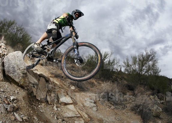
Santa Fe, New Mexico, is a popular destination for mountain bikers of all skill levels. The area offers a diverse range of trails, from easy, scenic rides to challenging, technical terrain. In this article, we’ll highlight the top 12 mountain bike trails in Santa Fe, so you can plan your next adventure.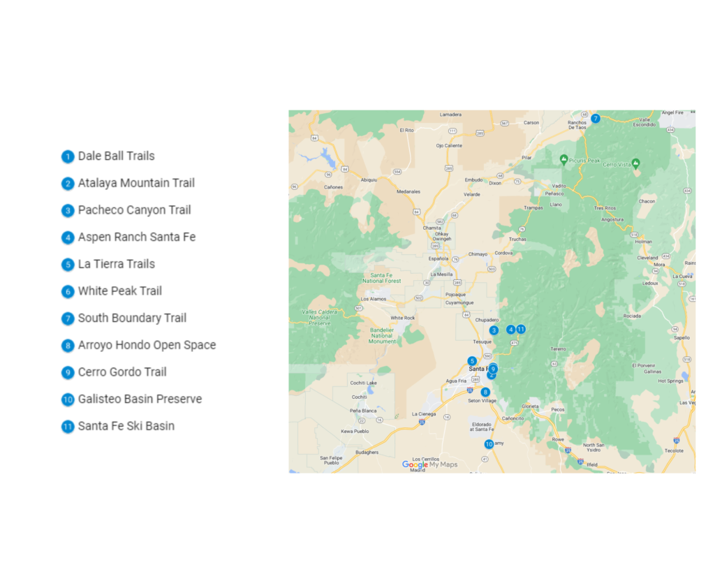
1. Dale Ball Trails
The Dale Ball bike trails are a network of over 25 miles of singletrack trails located in Santa Fe, New Mexico. These trails offer a variety of terrain for all skill levels, from easy beginner loops to technologically advanced descents.
The trail system is named after Dale Ball, a local Santa Fe resident and avid mountain biker who played a crucial role in its development. The trails wind through the beautiful Sangre de Cristo Mountains and offer stunning views of the surrounding landscape.
The trails are well-maintained and offer a great workout for both recreational riders and competitive athletes. Whether you’re a beginner or a seasoned pro, the Dale Ball bike trails have something for everyone. They are a must-ride for any mountain biker visiting Santa Fe.
| Features | Description |
| Location | Dale Ball |
| Length of trail | 25 miles |
| Loop, out and back or point to point? | Loop |
| Level of difficulty | Easy/Intermediate |
| How much is paved | Singletrack |
| Average time to complete | 2 hours 24 minutes |
| Stop-off points for food, water, restrooms | No |
2. Atalaya Mountain Trail
Atalaya Mountain is a challenging trail that offers stunning views of Santa Fe and is best suited for experienced hikers and mountain bikers. The trail starts off relatively easy and gradually becomes more difficult as it climbs steeply to the summit.
The summit offers a panoramic view of the surrounding area and is a great spot for a picnic or to simply take in the scenery. The descent from the summit is through rocky, technical terrain, which requires careful navigation and good balance.
Due to the challenging nature of the trail, it is rated as advanced and is best ridden in the cooler months, from October through April, since the heat can be intense during the summer months, making the trail more difficult to navigate.
The trail is approximately 8 miles long and takes an average of 46 minutes to complete. It is a great trail for those looking for a challenging outdoor adventure and an opportunity to take in the natural beauty of Santa Fe.
| Features | Description |
| Location | Atalaya Mountain |
| Length of trail | 8 miles |
| Loop, out and back or point to point? | Point to Point |
| Level of difficulty | Easy/Intermediate |
| How much is paved | Singletrack |
| Average time to complete | 46 minutes |
| Stop-off points for food, water, restrooms | No |
3. Pacheco Canyon Trail
The Pacheco Canyon Trail is a beautiful and challenging trail that takes riders through a remote canyon, offering a unique and rugged experience. The trail starts off with a steep climb that will test the rider’s endurance, but once at the top, the view is worth the effort.
The trail then descends through rocky terrain, with a series of technical sections that require skill and experience to navigate. The trail is rated as advanced and is best ridden in the cooler months, from October through April.
The trail is approximately 12 miles long and takes an average of 1 hour to complete. It is a great trail for those looking for a challenging outdoor adventure and an opportunity to take in the natural beauty of the remote canyon. The trail also offers a great opportunity for wildlife viewing, and visitors may spot a variety of animals, such as deer, elk, and coyotes, along the way.
| Features | Description |
| Location | Pacheco Canyon |
| Length of trail | 12 miles |
| Loop, out and back or point to point? | Point to Point |
| Level of difficulty | Easy/Intermediate |
| How much is paved | Singletrack |
| Average time to complete | 1 hour |
| Stop-off points for food, water, restrooms | No |
4. Aspen Ranch Trail
The Aspen Ranch Trail is a beautiful and easy trail that winds through a forest of aspen trees, offering a peaceful and scenic ride. The trail is great for beginners and families and is well-suited for those looking for a leisurely outdoor experience.
The trail is relatively flat and well-maintained, making it easy to navigate. The trail is best ridden in the summer months, from May through September, when the aspen trees are in full leaf, and the weather is warm and pleasant. The trail is approximately 4 miles long and takes an average of 23 minutes to complete.
Along the trail, visitors will be able to see the beautiful aspen trees up close and hear the rustling of the leaves as they sway in the breeze. The trail also offers a great opportunity for bird watching, and visitors may spot a variety of birds, such as the American goldfinch, the mountain bluebird, and the western tanager. The trail also offers a great opportunity to relax, unwind, and reconnect with nature.
| Features | Description |
| Location | Aspen Ranch |
| Length of trail | 4 miles |
| Loop, out and back or point to point? | Loop |
| Level of difficulty | Easy/Intermediate |
| How much is paved | Singletrack |
| Average time to complete | 23 minutes |
| Stop-off points for food, water, restrooms | No |
5. La Tierra Trails
The La Tierra Trails are a network of singletrack trails that offer a variety of riding options for mountain bikers of all levels. The trails are well-maintained and offer a mix of technical sections and smooth, flowy sections. This allows riders to test their skills and push their limits in a safe and controlled environment.
The trails are rated as intermediate in difficulty, making them suitable for riders with some experience, but they may still be challenging for some. The trail system is approximately 15 miles long and offers a great opportunity for riders to explore the beautiful natural surroundings of the area.
The trail system is best ridden in the cooler months, from October through April, when the weather is mild, and the trails are in optimal condition. This time of year also offers the opportunity to enjoy the vibrant fall colors of the trees. The trails are also popular with hikers and runners, so visitors should expect to encounter other trail users.
This trail system offers a great way to enjoy the outdoors and get some exercise while also having fun.
| Features | Description |
| Location | La Tierra |
| Length of trail | 15 miles |
| Loop, out and back or point to point? | Loop |
| Level of difficulty | Easy/Intermediate |
| How much is paved | Singletrack |
| Average time to complete | 1 hour 20 minutes |
| Stop-off points for food, water, restrooms | No |
6. White Peak Trail
The White Peak Trail is a challenging trail that takes riders to the summit of White Peak, offering an exhilarating and unforgettable experience. The trail is not for the faint-hearted, as it features steep climbs and rocky descents that test the rider’s endurance and technical skills.
The trail is rated as advanced and is best suited for experienced riders with a good level of fitness. The trail is approximately 6 miles long and takes an average of 34 minutes to complete. The trail is best ridden in the cooler months, from October through April, when the weather is mild, and the trails are in optimal condition.
This time of year also offers the opportunity to enjoy the vibrant fall colors of the trees. The summit of White Peak offers a panoramic view of the surrounding area and is a great spot for a picnic or to simply take in the scenery. Along the way, visitors may also spot a variety of wildlife, such as deer, elk, and coyotes.
The trail is also a great opportunity for bird watching, and visitors may spot a variety of birds, such as the American goldfinch, the mountain bluebird, and the western tanager. The trail is a great way to enjoy the outdoors, test oneself, and take in the natural beauty of the area.
| Features | Description |
| Location | White Peak |
| Length of trail | 6 miles |
| Loop, out and back or point to point? | Loop |
| Level of difficulty | Easy/Intermediate |
| How much is paved | Singletrack |
| Average time to complete | 34 minutes |
| Stop-off points for food, water, restrooms | No |
7. South Boundary Trail
The South Boundary Trail is a beautiful yet easy trail that takes riders through a remote canyon and offers a unique and scenic experience. The trail is well-suited for beginners and families and is relatively flat and well-maintained, making it easy to navigate.
The trail offers stunning views of the Sangre de Cristo Mountains, and visitors will be able to take in the natural beauty of the area and the diversity of the ecosystem. Along the trail, visitors will be able to see different types of vegetation, including a variety of wildflowers, cacti, and shrubs.
The trail is best ridden in the cooler months, from October through April, when the weather is mild, and the trails are in optimal condition. This time of year also offers the opportunity to enjoy the vibrant fall colors of the trees. The trail is approximately 10 miles long and takes an average of 46 minutes to complete.
It is a great trail for those looking for a leisurely outdoor adventure and an opportunity to take in the natural beauty of a remote canyon and the Sangre de Cristo Mountains.
| Features | Description |
| Location | South Boundary |
| Length of trail | 10 miles |
| Loop, out and back or point to point? | Loop |
| Level of difficulty | Easy/Intermediate |
| How much is paved | Singletrack |
| Average time to complete | 46 minutes |
| Stop-off points for food, water, restrooms | No |
8. Arroyo Hondo Open Space
The Arroyo Hondo Open Space is a beautiful and easy trail that takes riders through a picturesque valley, offering a peaceful and scenic ride. The trail is great for beginners and families and is well-suited for those looking for a leisurely outdoor experience.
The trail is relatively flat and well-maintained, making it easy to navigate. The trail is best ridden in the summer months, from May through September, when the weather is warm and pleasant and the greenery is lush. The trail is approximately 8 miles long and takes an average of 40 minutes to complete.
Along the trail, visitors will be able to see the beautiful valley up close and hear the soothing sound of the nearby stream. The trail also offers a great opportunity for bird watching, and visitors may spot a variety of birds, such as the American goldfinch, the mountain bluebird, and the western tanager.
The trail also offers a great opportunity to relax, unwind, reconnect with nature and escape from the hustle and bustle of everyday life. Additionally, the trail is also popular for hiking and running, so visitors should expect to encounter other trail users.
| Features | Description |
| Location | Arroyo Hondo Open Space |
| Length of trail | 8 miles |
| Loop, out and back or point to point? | Point to Point |
| Level of difficulty | Easy/Intermediate |
| How much is paved | Singletrack |
| Average time to complete | 40 minutes |
| Stop-off points for food, water, restrooms | No |
9. Cerro Gordo Trail
The Cerro Gordo Trail is a challenging trail that takes riders to the summit of Cerro Gordo, offering an exhilarating and unforgettable experience. The trail is not for the faint-hearted, as it features steep climbs, rocky descents, and technical sections that test the rider’s endurance and technical skills.
The trail is rated as advanced and is best suited for experienced riders with a good level of fitness. The trail is approximately 10 miles long and takes an average of 52 minutes to complete. The trail is best ridden in the cooler months, from October through April, when the weather is mild, and the trails are in optimal condition. This time of year also offers the opportunity to enjoy the vibrant fall colors of the trees.
| Features | Description |
| Location | Cerro Gordo |
| Length of trail | 10 miles |
| Loop, out and back or point to point? | Loop |
| Level of difficulty | Easy/Intermediate |
| How much is paved | Singletrack |
| Average time to complete | 52 minutes |
| Stop-off points for food, water, restrooms | No |
10. Galisteo Basin Preserve
The Galisteo Basin Preserve is a beautiful and easy trail that takes riders through a picturesque valley, offering a peaceful and scenic ride. The trail is great for beginners and families and is well-suited for those looking for a leisurely outdoor experience. The trail is relatively flat and well-maintained, making it easy to navigate.
The trail offers stunning views of the surrounding area, and visitors will be able to take in the natural beauty of the valley and the diversity of the ecosystem. Along the trail, visitors will be able to see different types of vegetation, including a variety of wildflowers, cacti, and shrubs. The trail is best ridden in the summer months, from May through September, when the weather is warm and pleasant and the greenery is lush.
The trail is approximately 6 miles long and takes an average of 30 minutes to complete. It is a great trail for those looking for a leisurely outdoor adventure and an opportunity to take in the natural beauty of a picturesque valley. Additionally, the trail is also popular for hiking, running, and bird watching, so visitors should expect to encounter other trail users.
| Features | Description |
| Location | Galisteo Basin Preserve |
| Length of trail | 6 miles |
| Loop, out and back or point to point? | Point to Point |
| Level of difficulty | Easy/Intermediate |
| How much is paved | Singletrack |
| Average time to complete | 30 minutes |
| Stop-off points for food, water, restrooms | No |
11. Santa Fe Ski Basin
The Santa Fe Ski Basin is a popular destination for mountain bikers in the summer months, offering a unique and exciting experience. The ski area offers lift-accessed downhill riding, providing an opportunity for riders to experience the thrill of going down the mountain at high speed.
The area also offers a variety of cross-country trails for riders to explore. These trails vary in difficulty, with some being more technical and challenging while others are more suitable for beginners. The trails are rated as intermediate to advanced in difficulty, making them suitable for riders with some experience, but they may still be challenging for some.
The trails are best ridden from June through September when the weather is mild. This time of year also offers the opportunity to enjoy the beautiful views of the surrounding area and the natural beauty of the mountains.
Additionally, the ski area offers amenities such as bike rentals, bike repair services, bike storage, and a bike park with features such as jump lines and pump tracks. The ski area also offers a variety of activities, such as hiking, camping, and picnicking, making it a great destination for a summer getaway.
| Features | Description |
| Location | Santa Fe Ski Basin |
| Length of trail | 9.59 miles |
| Loop, out and back or point to point? | Point to Point |
| Level of difficulty | Easy/Intermediate |
| How much is paved | Singletrack |
| Average time to complete | 55 minutes |
| Stop-off points for food, water, restrooms | Yes, portable toilets are available on route |
Conclusion
Santa Fe offers a diverse range of mountain bike trails for riders of all skill levels. From easy, scenic rides to challenging, technical terrain, there’s something for everyone. We hope this list of the top 11 mountain bike trails in Santa Fe helps you plan your next adventure.
Remember to always check with local biking clubs or outdoor websites like AllTrails for the most up-to-date and accurate information before visiting the trails. Happy riding!