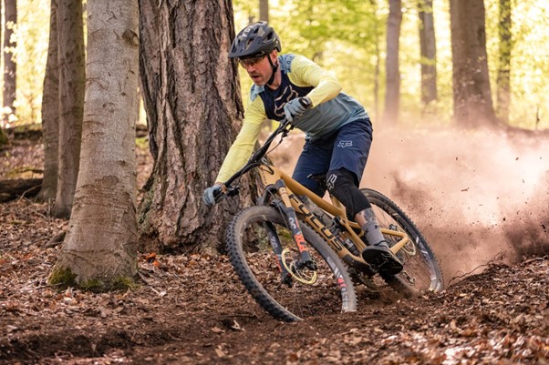
Charlotte, the largest city in North Carolina, is home to a diverse array of bike trails that cater to riders of all skill levels. Whether you’re a beginner looking for an easy, leisurely ride or an experienced cyclist searching for a challenging route, Charlotte has something to offer.
In this article, we’ll be highlighting the 12 best bike trails in Charlotte, so you can make the most of your cycling experience in the city.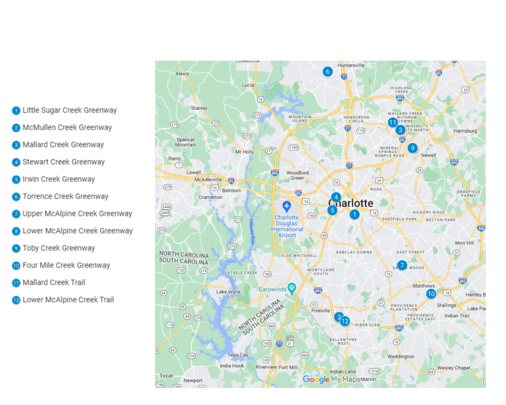
1. Little Sugar Creek Greenway
Little Sugar Creek Greenway is one of the most popular bike trails in Charlotte, North Carolina. This 7.5-mile trail runs through the heart of the city, offering a beautiful, paved path that’s perfect for families and beginner riders.
The Little Sugar Creek Greenway bike trail is well maintained, and it winds through a picturesque section of the city, passing by playgrounds, picnic areas, and sports fields, making it a great spot for a leisurely ride.
The trail is also pet-friendly, so you can bring your furry friends along for the ride. If you are looking for a great cycling experience in Charlotte, then the Little Sugar Creek Greenway bike trail is a must-see.
The trail offers a perfect mix of urban and nature, making it a great spot for a workout or a relaxing ride.
| Features | Description |
| Location | Little Sugar Creek Greenway |
| Length of trail | 7.5 miles |
| Loop, out and back or point to point? | Loop |
| Level of difficulty | Easy |
| How much is paved | Singletrack |
| Average time to complete | 37 minutes |
| Stop-off points for food, water, restrooms | Yes, portable toilets are available on route |
2. McMullen Creek Greenway
The McMullen Creek Greenway bike trail is a popular recreational path located in Charlotte, North Carolina. Spanning over 6 miles, the trail winds through wooded areas and wetlands, offering cyclists a serene and natural escape from the hustle and bustle of the city.
The trail is well-maintained, with smooth asphalt surfaces and clear signage, making it a great option for riders of all skill levels. Along the way, there are several access points where users can enter or exit the trail, including the McMullen Creek Greenway trailhead.
The trail also features beautiful views of McMullen Creek, many bird-watching opportunities, and benches for rest. This trail is a great option for those looking for a scenic and peaceful ride.
| Features | Description |
| Location | McMullen Creek Greenway |
| Length of trail | 6 miles |
| Loop, out and back or point to point? | Loop |
| Level of difficulty | Easy |
| How much is paved | Singletrack |
| Average time to complete | 30 minutes |
| Stop-off points for food, water, restrooms | Yes, portable toilets are available on route |
3. Mallard Creek Greenway
Mallard Creek Greenway is a picturesque trail located in Charlotte, providing a natural haven for outdoor enthusiasts. The trail winds for 6 miles through lush, green woods and past wetlands teeming with local wildlife, connecting several parks and neighborhoods along the way.
Whether you’re a cyclist, runner, walker, or nature lover, the well-maintained trail with smooth surfaces, convenient access points, and clear signage makes for an easy and enjoyable experience.
Highlights of the trail include the various bridges and boardwalks crossing over Mallard Creek, allowing for excellent bird watching and an up-close look at the creek’s ecosystem. Amenities such as benches and picnic tables are also available along the trail for visitors to take a rest and soak in the natural surroundings.
| Features | Description |
| Location | Mallard Creek Greenway |
| Length of trail | 6 miles |
| Loop, out and back or point to point? | Point to Point |
| Level of difficulty | Easy |
| How much is paved | Singletrack |
| Average time to complete | 30 minutes |
| Stop-off points for food, water, restrooms | Yes, portable toilets are available on route |
4. Stewart Creek Greenway
Stewart Creek Greenway is a serene trail located in the city of Charlotte, North Carolina. The trail is approximately 4 miles long and is ideal for outdoor enthusiasts who want to enjoy nature while getting some exercise.
The trail runs along Stewart Creek, which is surrounded by lush greenery, and it is known for providing a peaceful and natural escape from the city. The trail is well-maintained, with smooth surfaces, clear signage, and several access points making it easy for visitors to explore.
The Stewart Creek Greenway provides a unique opportunity to observe the Creek and its ecosystem, as well as to spot different types of birds and wildlife. The trail also has amenities such as benches and picnic tables for visitors to rest and enjoy the surroundings. It’s a great option for those looking for a scenic and tranquil ride.
| Features | Description |
| Location | Steward Creek Greenway |
| Length of trail | 4 miles |
| Loop, out and back or point to point? | Loop |
| Level of difficulty | Easy |
| How much is paved | Singletrack |
| Average time to complete | 20 minutes |
| Stop-off points for food, water, restrooms | Yes, portable toilets are available on route |
5. Irwin Creek Greenway
Irwin Creek Greenway is a tranquil trail located in the city of Charlotte, North Carolina. The trail is approximately 2 miles long. It is designed for walkers, runners, and cyclists that want to enjoy nature while getting some exercise.
The trail runs alongside Irwin Creek, which is surrounded by lush greenery and is known for providing a peaceful and natural escape from the city. The trail is well-maintained, with smooth surfaces, clear signage, and several access points making it easy for visitors to explore.
The Irwin Creek Greenway provides a unique opportunity to observe the Creek and its ecosystem, as well as to spot different types of birds and wildlife. The trail also has amenities such as benches and picnic tables for visitors to rest and enjoy the surroundings.
| Features | Description |
| Location | Irwin Creek Greenway |
| Length of trail | 2 miles |
| Loop, out and back or point to point? | Point to Point |
| Level of difficulty | Easy |
| How much is paved | Singletrack |
| Average time to complete | 11 minutes |
| Stop-off points for food, water, restrooms | Yes, portable toilets are available on route |
6. Torrence Creek Greenway
The Torrence Creek Greenway is a stunning trail located in Charlotte, North Carolina, that offers visitors a chance to enjoy nature while getting some exercise. The trail spans approximately 3 miles and follows the peaceful waters of Torrence Creek, surrounded by a lush green landscape that provides a natural escape from the city.
The well-maintained trail features smooth surfaces, clear signage, and several access points, making it easy for visitors to explore. Along the way, visitors can enjoy the unique opportunity to observe the Creek’s ecosystem and spot different types of birds and wildlife.
Amenities such as benches and picnic tables are also provided for visitors to rest and take in the natural beauty of the Torrence Creek Greenway.
| Features | Description |
| Location | Torrence Creek Greenway |
| Length of trail | 3 miles |
| Loop, out and back or point to point? | Loop |
| Level of difficulty | Intermediate |
| How much is paved | Singletrack |
| Average time to complete | 15 minutes |
| Stop-off points for food, water, restrooms | Yes, portable toilets are available on route |
7. Upper McAlpine Creek Greenway
The Upper McAlpine Creek Greenway is a beautiful and serene trail located in the city of Charlotte, North Carolina. The trail is approximately 4 miles long and offers a natural escape for walkers, runners, cyclists, and nature enthusiasts looking to enjoy the outdoors.
The trail follows the upper reaches of McAlpine Creek, surrounded by lush greenery and diverse wildlife, providing a unique opportunity to observe the creek’s ecosystem. The trail is well-maintained, with smooth surfaces and clear signage, and several access points, making it easy for visitors to explore.
Amenities such as benches and picnic tables are also provided for visitors to rest and enjoy the natural surroundings of the Upper McAlpine Creek Greenway. This trail is a great option for those looking for a scenic and peaceful ride.
| Features | Description |
| Location | Upper McAlpine Creek Greenway |
| Length of trail | 4 miles |
| Loop, out and back or point to point? | Point to Point |
| Level of difficulty | Intermediate |
| How much is paved | Singletrack |
| Average time to complete | 20 minutes |
| Stop-off points for food, water, restrooms | Yes, portable toilets are available on route |
8. Lower McAlpine Creek Greenway
The Lower McAlpine Creek Greenway is a breathtaking trail located in the city of Charlotte, North Carolina, that offers visitors the chance to enjoy the beauty of nature while getting some exercise.
The trail spans approximately 4 miles and follows the tranquil waters of Lower McAlpine Creek, surrounded by lush greenery and diverse wildlife. The well-maintained trail features smooth surfaces, clear signage, and several access points, making it easy for visitors to explore.
Visitors can take in the unique opportunity to observe the creek’s ecosystem and spot different types of birds and wildlife while enjoying a peaceful stroll, run, or bike ride. Amenities such as benches and picnic tables are provided along the trail for visitors to rest and take in the natural surroundings of the Lower McAlpine Creek Greenway.
| Features | Description |
| Location | Lower McAlpine Creek Greenway |
| Length of trail | 4 miles |
| Loop, out and back or point to point? | Point to Point |
| Level of difficulty | Intermediate |
| How much is paved | Singletrack |
| Average time to complete | 20 minutes |
| Stop-off points for food, water, restrooms | Yes, portable toilets are available on route |
9. Toby Creek Greenway
The Toby Creek Greenway is a tranquil trail located in the city of Charlotte. The trail is approximately 2 miles long and provides a natural escape for walkers, runners, cyclists, and nature enthusiasts looking to enjoy the outdoors.
The trail follows Toby Creek, which is surrounded by lush greenery and diverse wildlife, providing visitors with a unique opportunity to observe the creek’s ecosystem. The well-maintained trail with smooth surfaces, clear signage, and several access points is great for all skill levels of visitors.
Along the way, visitors can also enjoy amenities such as benches and picnic tables for rest and to take in the natural beauty of the Toby Creek Greenway. It’s a great option for those looking for a peaceful and scenic outdoor excursion on the Toby Creek Greenway.
| Features | Description |
| Location | Toby Creek Greenway |
| Length of trail | 2 miles |
| Loop, out and back or point to point? | Intermediate |
| Level of difficulty | Hard |
| How much is paved | Singletrack |
| Average time to complete | 11 minutes |
| Stop-off points for food, water, restrooms | Yes, portable toilets are available on route |
10. Four Mile Creek Greenway
The Four Mile Creek Greenway is a picturesque trail located in Charlotte, providing a natural haven for outdoor enthusiasts. The trail spans 4 miles and follows the peaceful waters of Four Mile Creek, surrounded by a lush green landscape and diverse wildlife.
Whether you’re a cyclist, runner, walker, or nature lover, the well-maintained trail with smooth surfaces, convenient access points, and clear signage makes for an easy and enjoyable experience.
Along the way, visitors can take in the unique opportunity to observe the Creek’s ecosystem and spot different types of birds and wildlife. Amenities such as benches and picnic tables are also provided for visitors to rest and take in the natural beauty of the Four Mile Creek Greenway. It’s a perfect destination for those who are looking for a serene and peaceful outdoor excursion.
| Features | Description |
| Location | Four Mile Creek Greenway |
| Length of trail | 4 miles |
| Loop, out and back or point to point? | Loop |
| Level of difficulty | Hard |
| How much is paved | Singletrack |
| Average time to complete | 21 minutes |
| Stop-off points for food, water, restrooms | Yes, portable toilets are available on route |
11. Mallard Creek Trail
The Mallard Creek 4-mile trail is perfect for intermediate riders. It features a mix of pavement and crushed stone and winds through a wooded area, offering a sense of adventure. The trail also passes by a playground and picnic area, providing a great spot for a break during your ride.
| Features | Description |
| Location | Mallard Creek Trail |
| Length of trail | 4 miles |
| Loop, out and back or point to point? | Point to Point |
| Level of difficulty | Hard |
| How much is paved | Singletrack |
| Average time to complete | 20 minutes |
| Stop-off points for food, water, restrooms | Yes, portable toilets are available on route |
12. Lower McAlpine Creek Trail
The Lower McAlpine Creek 5-mile trail is a more challenging option, perfect for experienced riders looking for a workout. It features a mix of pavement and crushed stone and winds through a densely wooded area, offering a sense of adventure and a bit of a workout. The trail also passes by a playground and picnic area, providing a great spot for a break during your ride.
| Features | Description |
| Location | Lower McAlpine Creek Trail |
| Length of trail | 5 miles |
| Loop, out and back or point to point? | Loop |
| Level of difficulty | Hard |
| How much is paved | Singletrack |
| Average time to complete | 25 minutes |
| Stop-off points for food, water, restrooms | Yes, portable toilets are available on route |
In Conclusion
These 12 bike trails in Charlotte offer something for riders of all skill levels and interests. Whether you’re a beginner looking for an easy, leisurely ride or an experienced cyclist searching for a challenging route, you’ll find a trail on this list that meets your needs.
Charlotte is a great city for cycling, and these 12 Best Bike Trails in Charlotte are a must-see for any cyclist visiting the city. So, grab your helmet and hit the trails!