Any season is perfect for mountain biking around Lake Tahoe as long as there isn’t more than a foot of snow in the Tahoe region. There are several breathtaking locations for mountain biking on lovely, straightforward routes throughout the lake basin in Tahoe, in addition to the world-famous Flume Trail.
In this article, we’ll check out 12 of the best bike trails for you to ride in Lake Tahoe!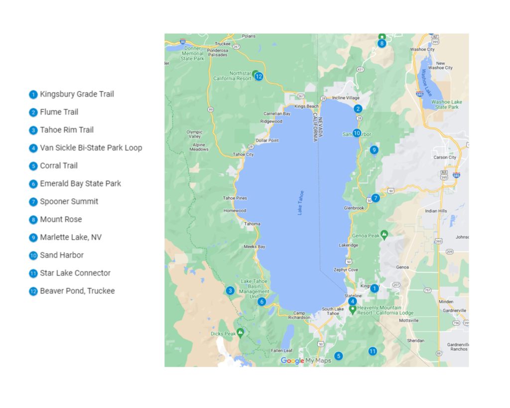
1. Kingsbury Grade Trail
Starting from the Daggett Summit Connector behind the fire station on Daggett Summit, the Kingsbury Grade loop can be completed in either a clockwise or counterclockwise direction.
To avoid having to climb the Daggett Loop Trail with its soft, loose, decomposed granite, many people opt to ride this loop counterclockwise. It’s not all bad, though, as going clockwise would let you ride the Tahoe Rim Trail downhill and give you the necessary speed to hit all the technical sections in a smooth flow that going the other way wouldn’t allow. You have a choice, and both are still very good ones.
Drive along Tina Court and park there but be aware of seasonal parking limitations. Take the Daggett Summit Connector, which starts off by crossing Highway 207 right in front of the fire station (be careful when doing so). Where you cross the road, beware of fast-moving traffic and the blind area for drivers cresting over Daggett Summitt.
At the trail intersection, turn right after the Daggett Loop Trail markers. Be prepared for a 3.5-mile ascent to the Kingsbury North trailhead parking area. From the parking area, take the connecting trail to the TRT’s T-junction, and then turn left.
This trail starts with a fantastic downhill segment with a number of optional jumps, rock features, and log rides. You’ll cross a creek in an aspen grove and start ascending again after a few stretches of climb and descent on the TRT. Shortly after leaving the aspen grove, look for a junction on the left to return to the Daggett Loop Trail. You will cross North Benjamin Drive and join the route across the street after a brief, strenuous ascent.
Keep a look out for the Daggett Summit Connector, which you rode up at the start of the route, as you ascend. Take this back to your car, where you started, to finish up.
| Features | Description |
| Location | Kingsbury Grade Trail |
| Length of trail | 11.5km |
| Loop, out and back or point to point? | Loop |
| Level of difficulty | Intermediate |
| Terrain | 429m Up & 430m Down |
| How much is paved | Singletrack |
| Average time to complete | 1 hour 25 minutes |
| Stop-off points for food, water, restrooms | Yes |
2. Flume Trail
Take a shuttle to the Tahoe Meadows Tahoe Rim Trail trailhead from the Tunnel Creek Cafe parking lot, where the ride finishes.
This ride’s morning start is frequently chilly; long sleeves or a shell are advised. Although they are few and far between, there are tiny triangular light blue and white Tahoe Rim Trail signs throughout the entire route that will direct you.
With your back to the road and facing the woods at the shuttle drop-off location, mount up and enter the trail on the right. The meadow’s route is extremely narrow and is lined by soft, lush vegetation. Be alert for minor obstructions that are concealed from sight. You enter the woods along a walkway made of broken wood. After a quarter mile, look for signs pointing up and right onto the Tahoe Rim Trail.
After the meadow, there is a 300′ climb, after which there are other smaller climbs and descents. This stretch of the trail is semi-technical because of the numerous rock stairs, which might be annoying to some. After biking for 9 miles, you reach a four-way stop.
5 miles more straight ahead in a straight line. You’ll experience a painful 900-foot ascent with numerous obstacles in this segment. You will hear the refrain, “Does this never let up?” You might just be soft, but you will have a hard time with this portion. You are rewarded for your ascent with Marlette Peak’s opening to a different meadow that offers breathtaking views.
A few hundred-foot detour leads to a viewpoint that takes in the beauty of Marlette and Tahoe Lakes. Return to the route, then descend 500 feet to Marlette Lake and join the Flume Trail there. The Flume Trail, a largely level singletrack that winds down a steep mountainside and drops barely 40 feet per mile, is excellent.
There is a notice alerting you of a very small area of rockslides that you will walk through. Enjoy the journey, eat lunch, and take in the scenery. The Flume comes to an end after a three-mile, 1500-foot fall to the Tunnel Creek Cafe. This may be a road, but the descent is enjoyable due to the numerous minor dips and drops that can be thrilling when traveling at high speed.
| Features | Description |
| Location | Flume Trail |
| Length of trail | 39.6km |
| Loop, out and back or point to point? | Point to point |
| Level of difficulty | Intermediate/difficult |
| Terrain | 443m Up & 1,177m Down |
| How much is paved | Doubletrack |
| Average time to complete | 5 hours 26 minutes |
| Stop-off points for food, water, restrooms | No |
3. Tahoe Rim Trail
This section of the TRT was not designed with mountain bikes in mind; thus, it is not a flow trail. This gives it some genuine character. There are many roots and off-camber twists, as well as smooth, rocky, and sandy areas when it’s dry.
Although this trail isn’t technically challenging, most beginners would find it too difficult. Although there are no particularly difficult climbs or descents, the lesser ones are steep and continuous enough to make a rider alert.
There are occasionally sharp rocks poking through the powdery surface, but no significant impediments or highly technical maneuvers are necessary.
| Features | Description |
| Location | The Brockway Summit Trailhead |
| Length of trail | 21km |
| Loop, out and back or point to point? | Point to point |
| Level of difficulty | Moderate |
| Terrain | 741m Up & 741m Down |
| How much is paved | Doubletrack |
| Average time to complete | 2 hours 30 minutes |
| Stop-off points for food, water, restrooms | No |
4. Van Sickle Bi-State Park Loop
This amazing ride combines complex abilities climbs, and descents with stunning views of Stateline, South Tahoe, Mt. Tallac, and the entire Lake. You start and finish at Van Sickle Bi-State Park, which is a short distance from a cold drink, a hot snack, and a shower.
| Features | Description |
| Location | Van Sickle Loop |
| Length of trail | 17km |
| Loop, out and back or point to point? | Point to point |
| Level of difficulty | Moderate |
| Terrain | 609m Up & 609m Down |
| How much is paved | singletrack |
| Average time to complete | 2 hours |
| Stop-off points for food, water, restrooms | No |
5. Corral Trail
You can join up to the Corral Trail with the Connection trail and other choices, or you can ride the trail on its own after climbing or taking the shuttle up the road. This fun singletrack has several rocky portions, built-up kickers near the bottom, and banked turns.
| Features | Description |
| Location | Corral Trail |
| Length of trail | 3.5km |
| Loop, out and back or point to point? | Point to point |
| Level of difficulty | Intermediate/difficult |
| Terrain | 14m Up & 218m Down |
| How much is paved | Singletrack |
| Average time to complete | 30 minutes |
| Stop-off points for food, water, restrooms | No |
6. Emerald Bay State Park
The trip up to and around Emerald Bay is one of the most beautiful roads around Lake Tahoe, and an out-and-back to Bliss State Park, which is just past Emerald Bay, from South Lake Tahoe, is a popular option. The distance to the beach at Bliss State Park and back from the Y intersection, where you can see Raley’s (intersection of Highways 50 and 89), is 26 miles.
| Features | Description |
| Location | Emerald Bay |
| Length of trail | 52km |
| Loop, out and back or point to point? | Loop |
| Level of difficulty | Intermediate/difficult |
| Terrain | 752m Up & 931m Down |
| How much is paved | Singletrack |
| Average time to complete | 30 minutes |
| Stop-off points for food, water, restrooms | No |
7. Spooner Summit
On Highway 50, just a short distance after Spooner Pass, there is ample parking for your visit to Spooner Summit. From the trailhead, the ascent begins right away with an average gradient of 10%. The loamy pine needle switchbacks are all relatively simple to navigate. Soak your time and take in the alpine surroundings, as there are a few spots where you can see the lake through the pine trees.
To the left is Duane Bliss Peak. The rising picks back up around approximately 3.5 miles in and averages about 9% grade for 1.5 miles (Strava Cat 3). However, the climbing becomes more challenging as you come across more loose rock and rock outcroppings that must be navigated. Hold on to hope! You’ll emerge from the trees and finish at a rock promontory with one of the most excellent views of the entire Lake just as you’re about to give up and hike it. You’re not even a third of the way there, so take a lengthy pause and have something to eat.
From here, it is all downhill but not as simple as you may expect. The Sierra Canyon Trail Junction is right past Genoa Peak, and you’ll rip down the next two miles on really enjoyable singletrack, in and out, and around open pine forest.
From this point on, each mile of biking gets harder and harder. Do not misunderstand; it is still a lot of fun! There is never a break on this trail. I faced every conceivable challenge on a daily basis. Drops, steps, sharp turns, up, down, around and through, and over. This walk offers everything. There aren’t many areas that let you take a break or even temporarily slide downward. Your arms will probably be more worn out than your legs, yet you will feel as though you have just completed two hours of calisthenics.
You’ll come across an increasing number of trail intersections as the path descends to Kingsbury slope. Keep to the Tahoe Rim Trail (TRT), which is prominently designated with a blue and white triangle emblem, for this journey. You’ll eventually hear the highway and emerge on road 207 at the Kingsbury grade. The TRT keeps going across the street and then resumes ascending. Before coming to an end at the following leg of the path, the Tahoe Rim Trail ascends past a junction with the Van Sickle Trail.
| Features | Description |
| Location | Spooner Summit |
| Length of trail | 28.4km |
| Loop, out and back or point to point? | Point to point |
| Level of difficulty | Intermediate |
| Terrain | 911m Up & 723m Down |
| How much is paved | Singletrack |
| Average time to complete | 4 hours 10 minutes |
| Stop-off points for food, water, restrooms | No |
8. Mount Rose
The Tahoe Rim Trail travels west at the start of this trip, which commences from the Mount Rose Summit parking lot on NV-431. The first five miles wind through sunlit stands of spruce and fir while navigating rock-strewn mountainside. You can see Mount Rose towering not too far away through openings in the foliage.
At the junction where a sign points out the trail to Mount Rose Summit, everything becomes much more exciting (the actual summit, not the trailhead). Following this downward, cross the creek, stop to enjoy a beautiful view of Galena Creek Falls, and then immediately start the ascent of the mountain.
The Mount Rose trail starts as a gentle climb through flower-filled alpine meadows with a great view of the valley. As the walk continues, the sights continue, but the gradual incline does not. It soon starts a gruelling ascent along a gully loaded with scree, gains a ridgeline for a brief reprieve, and then punches through the tree line with a series of switchbacks. At this point, the scenery becomes genuinely breathtaking, and you reach the summit ridge, where vistas extend in every direction.
Continue to the peak, where a stone windbreak stands for good reason, over the exposed ridgeline of fractured volcanic rock. If the day is calm, take your time and savor your well-earned dominance over the Carson Range.
| Features | Description |
| Location | Mount Rose |
| Length of trail | 16km |
| Loop, out and back or point to point? | Point to point |
| Level of difficulty | Intermediate |
| Terrain | 693m Up & 693m Down |
| How much is paved | Singletrack |
| Average time to complete | 4 hours 30 minutes |
| Stop-off points for food, water, restrooms | No |
9. Marlette Lake
Right below the kiosk at the summit of the North Canyon Road, climb from Spooner Lake to Marlette Lake; this route begins a challenging ascent on a fire road. It climbs for just 0.4 miles until the singletrack begins on your right as you reach the summit (look for signage).
The Marlette Lake trail has berms, kickers, and large granite rollers and is short, swift, and very flowy. At a dizzying speed, it slaloms and tunnels through lodgepole, Jeffrey, and ponderosa pines. The trail loosens up a little toward the bottom and becomes sandier, especially in the summer. You come to a stop at Chimney Beach Parking Area at the bottom, where you can cross the street and descend to the Lake Tahoe coast for a swim in the Big Blue.
The only options for returning from Chimney Beach are to take the road (which is extremely dangerous) or to ascend the Marlette Creek route (which is brutal). Therefore, your best option is to organize a shuttle where you can be picked up, relieving you of the burden of making the return trip.
| Features | Description |
| Location | Marlette Lake |
| Length of trail | 6.9km |
| Loop, out and back or point to point? | Point to point |
| Level of difficulty | Intermediate |
| Terrain | 59m Up & 573m Down |
| How much is paved | Singletrack |
| Average time to complete | 1 hour |
| Stop-off points for food, water, restrooms | No |
10. Sand Harbor
Near South Lake Tahoe, California, there is a 2-mile-long, somewhat well-traveled green singletrack path called Sand Harbor. This major mountain bike track has a 253-foot green climb and a general physical rating of easy. It may be utilized in both directions. This trail can be finished in around 24 minutes.
| Features | Description |
| Location | Tahoe Mountain, South Lake Tahoe, California |
| Length of trail | 2.7km |
| Loop, out and back or point to point? | Point to point |
| Level of difficulty | Easy |
| Terrain | 77m Up & 63m Down |
| How much is paved | Singletrack |
| Average time to complete | 24 Minutes |
| Stop-off points for food, water, restrooms | No |
11. Star Lake Connector
This 2011 path connects High Meadow to Star Lake and the TRT over 4 miles, climbing around 1,400 vertical feet. This well-built track is enjoyable to climb and descend. If you are descending from the TRT and Star Lake, join the Cold Creek path. Pedal up this path, continue to Freel Peak, then descend Armstrong, Connector, and Corral for a more extended circle, or do the opposite!
| Features | Description |
| Location | Freel High Country, South Lake Tahoe, California |
| Length of trail | 5.6km |
| Loop, out and back or point to point? | Point to point |
| Level of difficulty | Intermediate |
| Terrain | 343m Up & 5m Down |
| How much is paved | Singletrack |
| Average time to complete | 35 Minutes |
| Stop-off points for food, water, restrooms | No |
12. Beaver Pond Route Trail, Truckee
The Beaver Pond Route trail is a straight, simple road through the woods. Excellent for families and settling in. Depending on your mood, it connects to both simple paths and challenging terrain.
| Features | Description |
| Location | Donner Summit, Truckee, California |
| Length of trail | 597.8m |
| Loop, out and back or point to point? | Point to point |
| Level of difficulty | Easy |
| Terrain | 15m Up & 24m Down |
| How much is paved | Doubletrack |
| Average time to complete | 6 Minutes & 24 Seconds |
| Stop-off points for food, water, restrooms | No |