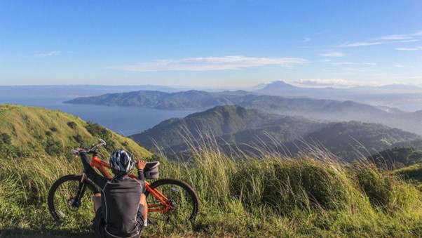
When you think about Hawaii, images of surf breakers, grass skirts, and pineapples are probably the first things that come to mind. But there also happen to be many cycling routes close by and scenery that was undoubtedly designed with cyclists in mind, so it’s time to add Maui to your list of cycling vacation spots.
Cycling is one of the best ways to experience more of Maui. We’ve examined all the cycling routes in the area to bring you the best 12, so you can choose your ideal bike ride in Maui County.
Although Maui appears to have a lot of open space, this is untrue. It is private land if it is not in a protected reserve. There are just two public mountain biking sites on Maui and riding is not permitted on any of the other trails on the island because they are all on private property.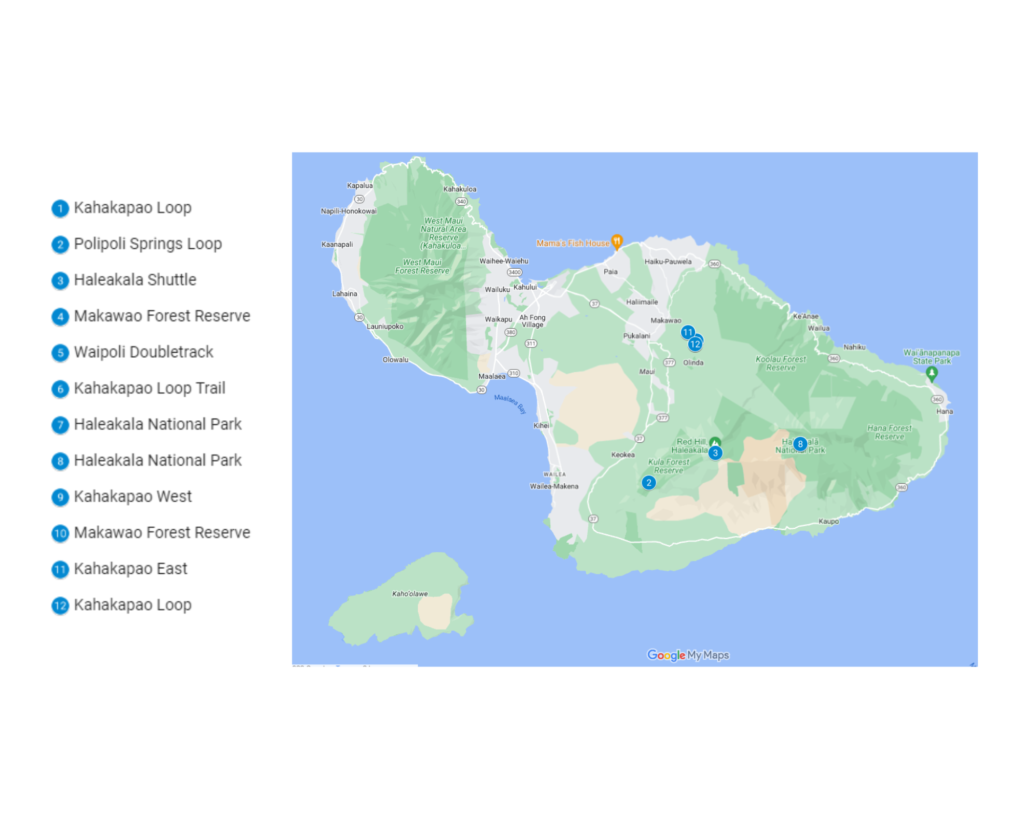
1. Kahakapao Loop
You may locate the Kahakapao Loop mountain bike track by driving just beyond Makawao Town (make sure to stop by Komoda’s in Makawao before or after your ride for some delectable baked goods).
It is approximately six miles long and gains height by around 1,000 feet. It’s a fantastic path for all skill levels, from fit kids to adults, unless it’s wet, in which case the terrain becomes slippery. We advise going counterclockwise around the path if you have children. If not, turn clockwise because the descent will be a bit more enjoyable.
The circle traverses a sizable portion of the Makawao Forest Reserve, an area of state territory covering around 2,000 acres on the extreme northwest sides of the East Maui volcano.
Both mountain biking and hiking are famous in this region. Both groups use the multi-use Kahakapao Loop, intersecting with bike-only routes such as the Pineapple Express, Renegade, and Ravine trails. In addition, a little escape from lowland beachgoing can be found by hiking the Kahakapao Loop Trail via the Makawao Forest Reserve.
After the rain, the Kahakapao Loop Trail, and especially the eastern leg, may get rather muddy. Therefore, it’s usually best to stay away from this climb on a wet day.
| Features | Description |
| Location | Makawao, HI 96768, United States |
| Length of trail | 9.59km |
| Loop, out and back or point to point? | Loop |
| Level of difficulty | Easy/Intermediate |
| Terrain | 291m Up & 291m Down |
| How much is paved | Singletrack |
| Average time to complete | 3 hours 11 minutes |
| Stop-off points for food, water, restrooms | Yes, portable toilets are available on route |
2. Polipoli Springs Loop
The southwest slopes of Haleakala provide an excellent, medium-sized loop called Polipoli Springs. It has a lot of double track but is also incredibly gorgeous and has a significant portion of singletrack called the Manane trail.
After a long drive up from Rice Memorial Park on Waipoli Rd, the ride begins at a tiny parking area at the top of Boundary Trail.
Get out of the Polipoli Springs region early for the bright sky and sunshine because it is frequently blanketed in foggy clouds by mid-morning.
Waipoli Rd is a steep, winding, and narrow road, but it is well worth the effort.
The most difficult portions are in the lower reaches, which include long stretches of rocks and stones. Nevertheless, the giant trees and scattered meadows make it one of the most picturesque places on earth.
| Features | Description |
| Location | Kula, HI 96790, United States |
| Length of trail | 13.7km |
| Loop, out and back or point to point? | Loop |
| Level of difficulty | Intermediate |
| Terrain | 384m Up & 387m Down |
| How much is paved | Doubletrack |
| Average time to complete | 3 hours |
| Stop-off points for food, water, restrooms | No |
3. Haleakala Shuttle
The Haleakala Shuttle journey begins close to the top of Haleakala, a 10,000-foot-tall dormant volcano on the island of Maui.
This route connects the Skyline (a double track made of cinders and pumice stone) to the Waipoli doubletrack before arriving at Rice Memorial Park. You may leave your car at the Boundary Trail access point on the Waipoli double track for a shorter journey.
The ride will take at least a half-day to accomplish. The road up to Haleakala’s peak is a protracted and twisting one, but it is also scenic.
You can reach Skyline from Haleakala National Park. You must pay the $10 admission charge at the entrance gate if you intend to see the views around the crater rim. However, you can be waived through for free if your goal is only to climb to the top of Skyline to begin the ride.
Wearing a full-face helmet and all available body armor is highly recommended. This section of the path is frequently dry, loose, and challenging to maneuver.
| Features | Description |
| Location | Haleakala National Park |
| Length of trail | 28.6km |
| Loop, out and back or point to point? | Loop |
| Level of difficulty | Intermediate |
| Terrain | 57m Up & 2,147m Down |
| How much is paved | Doubletrack |
| Average time to complete | 3 hours 30 minutes |
| Stop-off points for food, water, restrooms | No |
4. Tweener Trail, Makawao Forest Reserve
The Tweener is ideal for those new to off-road riding and mountain biking and a great alternative to the Kahakapao Loop.
Due to the high volume of hiker traffic on the main path, the Tweener trail is a popular descending alternative to the steeper Loop trail. It is also possible to see the Pineapple Express trail’s bottom segment in a few places.
| Features | Description |
| Location | Makawao Forest Reserve |
| Length of route | 0.4km |
| Loop, out and back or point to point? | Point to Point |
| Level of difficulty | Easy |
| Terrain | 0m Up & 31m Down |
| How much is paved | Singletrack |
| Average time to complete | 5 minutes 30 seconds |
| Stop-off points for food, water, restrooms | No |
5. Waipoli Doubletrack
The Skyline Downhill and many trails in the Polipoli Recreation area are connected to Waipoli Rd through the Waipoli Doubletrack.
The path begins close to the Boundary Trail entry point and concludes at the base of Skyline. The road is mainly level between Boundary and the Haleakala Ridge path. After there, the road slowly ascends to a three-way intersection. Skyline and Mamane are accessible through the left branch.
| Features | Description |
| Location | South Maui |
| Length of trail | 7.3km |
| Loop, out and back or point to point? | Point to Point |
| Level of difficulty | Intermediate |
| Terrain | 260m Up & 49m Down |
| How much is paved | Doubletrack |
| Average time to complete | 24 minutes |
| Stop-off points for food, water, restrooms | No |
6. Pineapple Express, Kahakapao Loop Trail
The Pineapple Express may be reached by ascending the Kahakapao Loop to the mountain’s summit.
Tune your suspension, then fly down this continuous descent. In true Hawaiian fashion, you’ll go from a mixed forest to a pine forest! The atmosphere is fantastic, and it is evident that this path was designed by experts!
There are jumps and large bank turns everywhere. Even a large wooden banked turn with several significant drops is included. I do not suggest using this trail while it is rainy, however.
More exposed roots on the Kahakapao East slope to Pineapple Express can make for a challenging climb in muddy or rainy conditions. Conversely, less exposed roots and a generally drier climate may be found on the Kahakapao West ascent to Pineapple Express.
| Features | Description |
| Location | Makawao Forest Reserve |
| Length of trail | 3km |
| Loop, out and back or point to point? | Point to Point |
| Level of difficulty | Easy |
| Terrain | 0m Up & 260m Down |
| How much is paved | Singletrack |
| Average time to complete | 16 minutes |
| Stop-off points for food, water, restrooms | No |
7. Skyline, Haleakala National Park
From a gate right outside Haleakala National Park, the Skyline begins. With the Big Island on the horizon, turn left onto a paved road and descend. The path then transforms to cinder and pumice stone, a terrain that can occasionally be quite difficult.
After passing beneath the observation towers, the Skyline swings back to the left before screaming across a lunar landscape. It’s perhaps one of the most unusual sights you may encounter on a bike, with earth tones in front of you and the deep Pacific Ocean below.
Before reaching the Mamane path, the route descends over a series of switchbacks above the Kula Forest Reserve.
To access the Waipoli doubletrack, continue on or turn right to enjoy the fantastic Mamane singletrack descent.
| Features | Description |
| Location | Haleakala National Park |
| Length of trail | 10.8km |
| Loop, out and back or point to point? | Point to Point |
| Level of difficulty | Intermediate |
| Terrain | 1m Up & 850m Down |
| How much is paved | Doubletrack |
| Average time to complete | 6 hours 30 minutes |
| Stop-off points for food, water, restrooms | No |
8. Mamane, Haleakala National Park
The Mamane mountain singletrack can be found in a cloud forest on Haleakala’s southwest slopes.
The Waipoli double track leads to Skyline and provides access to the higher end. With several whoops and twists, it starts among low shrubbery and grassy slopes. There are many possibilities to capture air, and the pleasure factor is tremendous.
With some loose cobble and little dips, the terrain becomes a little bit more challenging in the middle segment. You’ll find yourself riding through large, bushy pine trees as the tree cover changes.
The most difficult portions are in the lower reaches, which include long stretches of rocks and stones. The giant trees and scattered meadows in the forest make it one of the most picturesque places on earth. Unfortunately, you’ll also encounter mist unless you head out on the trek first thing in the morning.
| Features | Description |
| Location | Polipoli Spring State Recreation Area |
| Length of trail | 2.9km |
| Loop, out and back or point to point? | Point to Point |
| Level of difficulty | Easy |
| Terrain | 0m Up & 239m Down |
| How much is paved | Singletrack |
| Average time to complete | 13 minutes |
| Stop-off points for food, water, restrooms | No |
9. Kahakapao West
The Kahakapao East route’s summit is where the west side Kahakapao singletrack begins. The hike starts with a steep, bench-cut track and descends through drainage to a vast, open-canopied forest of luxuriant ferns and eucalyptus trees.
Following a brief ascending pitch, the route continues to drop progressively over a sequence of twists. The forest is often more open on this side of the Kahakapao Loop. The terrain is a little bit dryer as well.
Watch for the red badges on the trees to stay on the singletrack as the trail crisscrosses an ancient double-track path.
The final stretch of Kahakapao West passes through a stunning area of lush, green rainforest that is home to several ferns and moss-covered boulders.
| Features | Description |
| Location | Makawao Forest Reserve |
| Length of trail | 4.1km |
| Loop, out and back or point to point? | Point to Point |
| Level of difficulty | Easy |
| Terrain | 7m Up & 262m Down |
| How much is paved | Singletrack |
| Average time to complete | 33 minutes |
| Stop-off points for food, water, restrooms | No |
10. Ravine, Makawao Forest Reserve
The Ravine travels down a gorge before passing into the Makawao Forest Reserve. The initial part of the trail is a smooth singletrack that winds through the forest, but it quickly dips into a canyon and the route becomes a little more complicated.
The route subsequently leaves the canyon, providing several opportunities to take a breather. It is actually relatively brief, but it is worth a go. The Ravine Trail has jumps, berms, and a challenging finish portion off the Kahakapao West Loop Trail.
Look before you leap! This is a challenging trail with freshly improved features and alternatives.
| Features | Description |
| Location | Makawao Forest Reserve |
| Length of trail | 0.8km |
| Loop, out and back or point to point? | Point to Point |
| Level of difficulty | Easy |
| Terrain | 0m Up & 77m Down |
| How much is paved | Singletrack |
| Average time to complete | 9 minutes |
| Stop-off points for food, water, restrooms | No |
11. Kahakapao East
A little way up the double track from the kiosk is where the east side of the Kahakapao singletrack begins. Keep to the right to follow the route that has red badges on the trees.
The east side, which is the ascent for the Kahakapao Loop, has a constant but not consistently severe incline. With multiple curves, it generally runs through deep woodland. However, the majority of the route is level, covered with leaves, and includes a few roots for interest.
At the peak of the ascent, there is a crossroads. Either turn left to access Fong Ridge Road or stay to the right to continue on Kahakapao West.
The Makawao Flow Path is easily accessible from this trail as well.
| Features | Description |
| Location | Makawao Forest Reserve |
| Length of trail | 4.1km |
| Loop, out and back or point to point? | Point to Point |
| Level of difficulty | Easy |
| Terrain | 248m Up & 0m Down |
| How much is paved | Singletrack |
| Average time to complete | 50 minutes |
| Stop-off points for food, water, restrooms | No |
12. Renegade, Kahakapao Loop
The Renegade begins at the summit of Kahakapao Loop and continues through the lush Makawao Forest before coming to an end at the entrance of the Ravine.
The route has several roots, making it somewhat slick when wet. The path has fewer jumps and is more akin to classic singletrack. You’ll eventually find yourself in a pine tree forest, which will radically alter the scenery.
There aren’t many chances to get some air, but this one is more about getting a good look at the trees than blasting down and taking off like crazy. A handful of the flat areas require you to pedal.
For an entire singletrack ride to the parking lot, try combining it with the Ravine and Tweener.
| Features | Description |
| Location | Makawao Forest Reserve |
| Length of trail | 2.1km |
| Loop, out and back or point to point? | Point to Point |
| Level of difficulty | Easy |
| Terrain | 1m Up & 144m Down |
| How much is paved | Singletrack |
| Average time to complete | 14 minutes |
| Stop-off points for food, water, restrooms | No |
Conclusion
Due to its numerous health advantages and recreational uses, mountain biking has become very popular in Hawaii. You can never get tired of riding a mountain bike in this area since there are so many gorgeous and spectacular paths. The paths mentioned above are worth your time and effort if you’re a visitor to Hawaii looking for something new to explore.