
Are you a cyclist planning your trip to Miami? Well, I have some good news for you! A bike ride can be a terrific way to unwind from your busy life. Cyclists in the Miami region have a wide choice and wide variety of bike trails for all rider levels.
You may come across trails that run directly along the shore or through the Everglades. Urban trails offer a close-up view of the city, while more isolated tracks immerse you in the area’s stunning natural habitat. Miami-Dade provides every kind of biking activity imaginable.
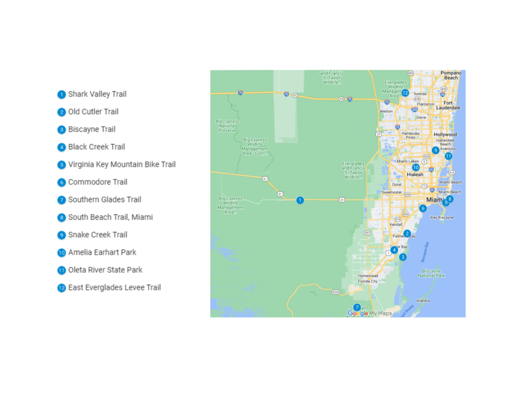
Read on for our top 12 Miami bike trails.
1. Shark Valley Trail
One of the most unique rides in America is the Shark Valley Trail, located at the North Entrance of the Everglades National Park. Alligators are a fantastic representation of Florida; on this trail, you can literally ride or trek among them.
Shark Valley Trail is a 14.7-mile asphalt loop that can be reached on foot, by bicycle, or by tram. It is situated off Tamiami Trail (US Highway 41) west of Miami, close to the Miccosukee Indian Reservation.
Bring your own bicycle or hire one at the visitor center. Panoramic views of the “river of grass” are available from the 65-foot observation tower. Despite being far away, it is well worth the trek.
| Features | Description |
| Location | Dade County |
| Length of trail | 14.7 miles |
| Loop, out and back or point to point? | Loop |
| Level of difficulty | Easy |
| Terrain | flat |
| How much is paved | Singletrack |
| Average time to complete | 4 hours |
| Stop-off points for food, water, restrooms | No |
2. Old Cutler Trail
Under the shade of magnificent fichus trees and banyans, the 13.5-mile Old Cutler Trail passes through some of the most picturesque areas in the greater Miami area. Matheson Hammock Park, Fairchild Tropical Garden, and Pinecrest Gardens are a few of the well-liked destinations along the route.
Families and individuals who love taking slow walks or rides are best suited for the trail. Although it is legal to inline skate, much of the path is raked with tree roots.
The intersection of Old Cutler Road, Sunset Road, and LeJune Road in Coral Gables is where you’ll find the northern trailhead. The southern trailhead is located in Cutler Bay, near the intersection of SW 87th Avenue and Old Cutler Road. You can join the 2.7-mile Biscayne Trail at its southern terminus, which offers a beautiful path that leads down to Biscayne Bay. An offshoot along 216th also connects the Black Creek Trail.
| Features | Description |
| Location | Miami Dade |
| Length of trail | 13.5 miles |
| Loop, out and back or point to point? | Point to point |
| Level of difficulty | Easy |
| Terrain | Flat |
| How much is paved | Singletrack |
| Average time to complete | 3 hours 42 min |
| Stop-off points for food, water, restrooms | Yes, there are restrooms available on the track. |
3. Biscayne Trail
The Old Cutler Trail, an 11-mile north-south trail, ends at its southernmost point where the Biscayne Trail starts. The Biscayne Trail then passes through residential areas along SW 87th Avenue, but as it heads south, you’ll find yourself in a lush, tree-lined setting. It offers a crucial and secure path for kids because it passes close to Dr. Wingham Elementary School and Centennial Middle School.
The walk comes to a conclusion at Black Point Park & Marina, which offers easy access to Biscayne Bay’s glistening waters and a sizable pavilion for picnics. Trail users can continue their adventure on Miami’s Black Creek Trail, close to its southernmost point.
| Features | Description |
| Location | Biscayne Trail |
| Length of trail | 2.7 miles |
| Loop, out and back or point to point? | Loop |
| Level of difficulty | Easy |
| Terrain | Flat |
| How much is paved | Singletrack |
| Average time to complete | 42 minutes |
| Stop-off points for food, water, restrooms | No |
4. Black Creek Trail
From Orange Park south to Black Creek Park, close to Lakeside, FL, just south of Jacksonville, the Black Creek Trail runs alongside U.S. Highway 17. The trail winds through picturesque wetlands and forested areas as it crosses Fleming Island, a river inlet bordered on the west by Doctor’s Lake and the St. Johns River on the east.
The 255-acre wildlife preserve and nature park Moccasin Slough Park, which is home to alligators, bald eagles, and several waterfowl species, is visible from the route. Along Raggedy Point Road, there are picnic spots, a gazebo, a playground, and a building for environmental education activities in the recently constructed park. In addition, there are wetlands boardwalks with observation platforms, a kayak launch, and upland trails.
When navigating the trail’s numerous intersections, do proceed with considerable caution! Crossing the junctions at Pace Island and CR 220 in Eagle Harbor should be done with extra care. The time of the “walk” signs is relatively brief, and right-turning vehicles frequently ignore them.
| Features | Description |
| Location | Northern Floria, Green Cove Springs |
| Length of trail | 8.5 miles |
| Loop, out and back or point to point? | Loop |
| Level of difficulty | Easy |
| Terrain | 9m Up & 10m Down |
| How much is paved | Singletrack |
| Average time to complete | 2 hours and 20 min |
| Stop-off points for food, water, restrooms | No |
5. Virginia Key Mountain Bike Trail
This 6.4-km circular route may be found close to Miami, Florida. It typically takes 1 hour and 26 minutes to accomplish this trip, which is thought of as being simple. Since mountain biking is highly popular in this region, you can run into other riders while exploring.
The route is lovely to explore at any time of the year and is open all year. Dogs must stay at home because this trail is off-limits to them.
| Features | Description |
| Location | Florida |
| Length of trail | 6.4km |
| Loop, out and back or point to point? | Loop |
| Level of difficulty | Easy |
| Terrain | 21m Up & 10m Down |
| How much is paved | Singletrack |
| Average time to complete | 1 hour 26 min |
| Stop-off points for food, water, restrooms | No |
6. Commodore Trail
The 5-mile Commodore Trail is paved and follows a number of streets, including South Miami Avenue, Bayshore Drive, Main Highway, and Douglas Road. The Alice Wainwright Park, Museum of Science/Planetarium, Vizcaya Museum, Kennedy Park, Peacock Park, and the Barnacle Historic State Park are some of the attractions that may be seen on the trip.
The Old Cutler Trail, an 11-mile trail that passes through some of the most picturesque communities in the greater Miami area, begins just on the opposite side of the roundabout from where it has its southern terminus. The track changes throughout its journey from dedicated paths to shoulders to expanded roads, so some vigilance is required.
| Features | Description |
| Location | Florida |
| Length of trail | 5 miles |
| Loop, out and back or point to point? | Point to point |
| Level of difficulty | Easy |
| Terrain | Flat |
| How much is paved | Singletrack |
| Average time to complete | 1 hour and 18 min |
| Stop-off points for food, water, restrooms | No |
7. Southern Glades Trail
The Southern Glades Trail runs along the eastern edge of Everglades National Park, outside of Florida City, in the state’s southeast corner. It follows the C-111 canal for 13 miles; at its northern end, the path borders the west side of the canal; however, for its southern half, the trail turns to the eastern side of the canal.
The trail descends to Manatee Bay through tranquil state-owned wildlife habitat. You might see deer, alligators, snakes, and many birds along the road. Because of the gravelly surface of the pathway, mountain bikes or hybrids are advised. Horses are also permitted. Be aware that there are no toilets or water sources along the route, so pack accordingly.
| Features | Description |
| Location | Southern Glades trail, Florida |
| Length of trail | 13 miles |
| Loop, out and back or point to point? | Point to point |
| Level of difficulty | Easy |
| Terrain | Flat |
| How much is paved | Singletrack |
| Average time to complete | 3 hours and 45 min |
| Stop-off points for food, water, restrooms | No |
8. Atlantic Greenway (South Beach Trail)
This track, also known as the South Beach Trail, is tucked away in one of the nation’s most well-liked vacation spots and meanders through South Beach. With stunning views of the Atlantic Ocean, Miami Beach serves as the location of both of the trail’s endpoints.
The trail becomes increasingly busy with folks out walking as it gets closer to South Beach’s famous hotels and bars. Many people use the route to enjoy the beautifully bathtub-like Miami ocean water.
There are vast, grassy sections with exercise locations and volleyball courts, longboarders, street artists, and plenty of people using the trail.
| Features | Description |
| Location | Atlantic Greenway, Florida |
| Length of trail | 9.3 miles |
| Loop, out and back or point to point? | Loop |
| Level of difficulty | Easy |
| Terrain | Flat |
| How much is paved | Singletrack |
| Average time to complete | 2 hours and 10 min |
| Stop-off points for food, water, restrooms | No |
9. Snake Creek Trail
The Snake Creek Trail in southeast Florida is one of the finer local paths. The paved 6.5-mile path, which connects North Miami Beach and Miami Gardens, provides a comfortable, flat riding experience along a canal filled with palm trees. Since there are plenty of stores, eateries, schools, and companies close to the trail, it serves as an important transportation route.
The amenities along the trails include little parks, picnic areas, and exercise facilities. Although the Snake Creek Canal is primarily utilized for flood management, it is also used for jet skiing, kayaking, and canoeing down to Biscayne Bay.
There are plans to extend the trail to 18 kilometers, and maybe even further west to US 27. The westward extension is currently being researched to carry the trail past Florida’s Turnpike, giving a quick and traffic-free way to access the Sun Life Stadium (home of the Miami Dolphins). As soon as a solution to cross or go under the busy road is found, an eastern extension would carry the route to Biscayne Boulevard and beyond.
| Features | Description |
| Location | Snake Creek, Florida |
| Length of trail | 6.5 miles |
| Loop, out and back or point to point? | Point to Point |
| Level of difficulty | Easy |
| Terrain | 12m Up & 10m Down |
| How much is paved | Singletrack |
| Average time to complete | 1 hour 52 min |
| Stop-off points for food, water, restrooms | Yes, there are picnic areas and exercise facilities along the route. |
10. Amelia Earhart Park
You can venture off the main road and onto a mile-long forest mountain bike trail with challenging slopes and runs by mountain biking at Amelia Earhart Park. There is no cost to use the trails (although parking is not free). Amelia is a fast-paced park with lots of flow; no access roads or double tracks are necessary because one trail ends at the entrance to the next.
With optional jumps and challenging trail features, there is plenty for all levels of ability. The trails run entirely clockwise or counter-clockwise. To protect the paths, avoid this location while it’s raining or after a lot of rain.
There are over 13 different trails to choose from when going to Amelia Earhart Park, with trails ranging from beginner level all the way to expert. Potato Vine is one of the most highly rated trails in Amelia Earhart Park, with over 90 five-star reviews.
| Features | Description |
| Location | Potato Vine, Amelia Earhart Park
Hialeah, Florida |
| Length of trail | 1.2km |
| Loop, out and back or point to point? | Loop |
| Level of difficulty | Easy |
| Terrain | 12m Up & 10m Down |
| How much is paved | Singletrack |
| Average time to complete | 3 minutes 52 seconds |
| Stop-off points for food, water, restrooms | No |
11. Oleta River State Park
Oleta River State Park, Florida’s largest urban park, is situated on Biscayne Bay in the bustling Miami metropolitan region.
Despite providing a variety of recreational options, the park is most renowned for its miles of off-road cycling paths, which range from easy routes for beginners to difficult routes for seasoned riders. Over the Miami Metropolitan area trail network, Oleta boasts the largest trail mileage.
At the park’s northernmost point, and running beside the Oleta River, a lovely mangrove forest showcases local South Florida flora and fauna. Kayakers and canoeists may explore this magnificent natural environment by paddling the river. Saltwater fishing and swimming from a 1,200-foot sandy beach are other popular pastimes. There are barbecues and picnic tables available. There is a cost for renting the one big picnic pavilion and the eight smaller pavilions. White Ibis, a large picnic pavilion, provides electricity.
With over 15 different trails to choose from at Oleta River State Park, there will be something for everyone! Some of the most common trails in the park include Stairway to Heaven, Dragons Gate, Gator Bank, El Diablo, and Volunteer Trail.
Here are the features for the most common trail, Dragon’s Gate.
| Features | Description |
| Location | Dragon’s Gate Oleta River State Park, North Miami Beach, Florida |
| Length of trail | 320m |
| Loop, out and back or point to point? | Point to Point |
| Level of difficulty | Easy |
| Terrain | 2m Up & 2m Down |
| How much is paved | Singletrack |
| Average time to complete | 1 minute 20 seconds |
| Stop-off points for food, water, restrooms | No |
12. East Everglades Levee Trail
In Miami, the East Everglades Levee Trail is arguably the best of them all. More animals will be present than on any other Florida route. Alligators, many bird species, snakes, and turtles can be seen, along with deer, bears, and occasionally riders. The levees that regulate the Everglades’ water flow are crossed by the route. Although the top-of-levee route is level, sandy, and rocky, there are several detours that may be taken.
The trails are wholly located inside County and National parks, and South Florida Water Management is responsible for their upkeep. Everglades Holiday Park, Krome Avenue, and Tamiami Trail all have a number of trailhead entrances. The Tamiami section and the Everglades Holiday Park trailheads both feature camping facilities, and the route passes through several Everglades ecosystems. The course has enough drops and rugged terrain for technical riders. The 68-mile path can be completed all at once or in sections.
Many of the side levees do not span canals, so before taking a 10-mile shortcut, make sure to grab a map of the levee or study Google Earth. Otherwise, you could find that you have to swim with gators and snapping turtles to get across or walk back. Every canal is too deep for a bicycle to cross.
Water is all around you, yet it needs to be cleaned. On the Tamiami stretch and the Everglades Holiday Park Trailheads, there is potable water accessible. The most comfortable months to cycle the path are December through April.
| Features | Description |
| Location | East Everglades Levee Trail, Everglades Holiday Park, Florida |
| Length of trail | 109.4km |
| Loop, out and back or point to point? | Loop |
| Level of difficulty | Intermediate |
| Terrain | Unknown |
| How much is paved | Singletrack |
| Average time to complete | Unknown |
| Stop-off points for food, water, restrooms | Yes, there are camping facilities such as restrooms on the trail. |
Conclusion
There is a lot to see in Miami and exploring it on two wheels can offer you the opportunity to take it all in. This city makes a beautiful destination for a bicycle tour because of its amazing beaches, breathtaking skylines, and gorgeous natural areas teeming with wildlife. You can lengthen your ride to suit your mood, thanks to the many connected routes.