Sacramento, California, is a great city for cycling enthusiasts, with a variety of biking trails that cater to riders of all skill levels. Here are 12 of the best biking trails in the Sacramento area that are worth checking out.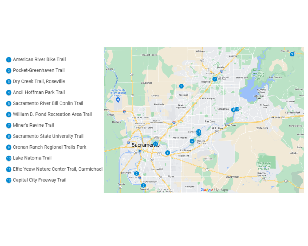
1. American River Bike Trail
The American River Bike Trail is a popular and scenic recreational trail that follows the American River in California. The trail runs for 32 miles, starting in Old Sacramento and ending at Folsom Lake. It is a flat, paved trail that is suitable for riders of all skill levels, and it is a popular destination for cycling, walking, and running.
The trail offers beautiful views of the river and the surrounding landscape, and it passes through several parks and natural areas. Along the way, there are a number of amenities available, including restrooms, drinking fountains, and picnic areas. There are also several access points along the trail, so you can choose to ride as much or as little as you like.
Overall, riding the American River Bike Trail can be a very enjoyable experience. It is a great way to get some exercise and enjoy the outdoors, and the scenery along the trail is beautiful. Just be sure to follow proper trail etiquette, such as staying to the right, yielding to pedestrians, and using hand signals when turning.
| Features | Description |
| Location | Sacramento, California |
| Length of trail | 52km |
| Loop, out and back or point to point? | Point to Point |
| Level of difficulty | Intermediate |
| Terrain | 280m Up & 280m Down |
| How much is paved | Singletrack |
| Average time to complete | 7 hours 52 minutes |
| Stop-off points for food, water, restrooms | Yes, there are restrooms on the trail. |
2. Pocket-Greenhaven Trail
The Pocket-Greenhaven bike trail is a popular destination for cycling enthusiasts in the Sacramento area. Located in the Pocket-Greenhaven neighborhood, this easy, flat trail offers a peaceful ride through a residential area.
One of the best things about the Pocket-Greenhaven bike trail is its accessibility. It is located just a few miles south of downtown Sacramento, making it easy to reach from most parts of the city. The trail is also suitable for all skill levels, making it a great option for beginners and families.
In addition to its convenience and accessibility, the Pocket-Greenhaven bike trail is also a great option for those looking to enjoy some beautiful scenery. The trail winds through the Pocket-Greenhaven neighborhood, offering riders the chance to take in the sights and sounds of this charming community.
| Features | Description |
| Location | Pocket-Greenhaven |
| Length of trail | 4.4 miles |
| Loop, out and back or point to point? | Loop |
| Level of difficulty | Intermediate |
| Terrain | 62m Up & 62m Down |
| How much is paved | Singletrack |
| Average time to complete | 36 minutes |
| Stop-off points for food, water, restrooms | No |
3. Dry Creek Trail
The Dry Creek Trail is a recreational trail located in Roseville, California. It is a paved trail that runs for approximately 6 miles through the city, following the course of Dry Creek. The trail is suitable for riders of all skill levels and is popular for cycling, walking, and running.
The Dry Creek Trail offers a mix of urban and natural scenery, passing through residential areas, parks, and open spaces. Along the way, there are a number of amenities available, including restrooms, drinking fountains, and picnic areas. There are also several access points along the trail, so you can choose to ride as much or as little as you like.
| Features | Description |
| Location | Roseville, California |
| Length of trail | 5.4km |
| Loop, out and back or point to point? | Loop |
| Level of difficulty | Intermediate |
| Terrain | 157m Up & 367m Down |
| How much is paved | Singletrack |
| Average time to complete | 28 minutes |
| Stop-off points for food, water, restrooms | Yes |
4. Ancil Hoffman Park Trail
Ancil Hoffman Park is a large park located in Carmichael, California, near Sacramento. It features a number of trails that are suitable for biking, as well as other recreational activities such as hiking and running.
The trails at Ancil Hoffman Park vary in length and difficulty, offering something for riders of all skill levels. Some of the trails are paved, while others are unpaved and more rugged. The park is known for its beautiful natural scenery, with trees, rolling hills, and views of the American River.
| Features | Description |
| Location | Carmichael, California |
| Length of trail | 4.8km |
| Loop, out and back or point to point? | Loop |
| Level of difficulty | Intermediate |
| Terrain | 25m Up & 25m Down |
| How much is paved | Singletrack |
| Average time to complete | 24 minutes |
| Stop-off points for food, water, restrooms | Yes |
5. Sacramento River Bill Conlin Trail
The Bill Conlin Trail is a recreational trail located in Sacramento, California. It is a paved trail that runs for approximately 3 miles through the city, following the course of the American River. The trail is suitable for riders of all skill levels and is popular for cycling, walking, and running.
The Bill Conlin Trail offers beautiful views of the river and the surrounding landscape, and it passes through several parks and natural areas. Along the way, there are a number of amenities available, including restrooms, drinking fountains, and picnic areas. There are also several access points along the trail, so you can choose to ride as much or as little as you like.
6. William B. Pond Recreation Area Trail
The William B. Pond Recreation Area Trail is a must-visit destination for cycling enthusiasts in the Sacramento area. Located in Carmichael, this network of trails offers a variety of terrain for mountain bikers, including single-track and dirt trails.
One of the best things about the William B. Pond Recreation Area Trail is its natural beauty. The trails wind through a wooded area, offering riders the chance to take in the sights and sounds of the surrounding wilderness. The area is also home to a variety of wildlife, including birds and small animals, making it a great place for nature lovers.
In addition to its natural beauty, the William B. Pond Recreation Area Trail is also a great place for those looking to get in a good workout. The trails offer a variety of terrain, ranging from easy, flat sections to more challenging, hilly areas. Whether you are an experienced mountain biker or just getting started, there is something for everyone at the William B. Pond Recreation Area Trail.
| Features | Description |
| Location | Carmichael |
| Length of trail | 9.8km |
| Loop, out and back or point to point? | Loop |
| Level of difficulty | Intermediate |
| Terrain | – |
| How much is paved | Singletrack |
| Average time to complete | 1 hour 12 minutes |
| Stop-off points for food, water, restrooms | No |
7. Miner’s Ravine Trail
The Miner’s Ravine Trail is a recreational trail located in Roseville, California, near Sacramento. It is a paved trail that runs for approximately 7 miles through the city, following the course of Miner’s Ravine. The trail is suitable for riders of all skill levels and is popular for cycling, walking, and running.
The Miner’s Ravine Trail offers a mix of urban and natural scenery, passing through residential areas, parks, and open spaces. Along the way, there are a number of amenities available, including restrooms, drinking fountains, and picnic areas. There are also several access points along the trail, so you can choose to ride as much or as little as you like.
| Features | Description |
| Location | Roseville |
| Length of trail | 7 miles |
| Loop, out and back or point to point? | Point to Point |
| Level of difficulty | Intermediate |
| Terrain | 96m Up & 96m Down |
| How much is paved | Singletrack |
| Average time to complete | 1 hour 36 minutes |
| Stop-off points for food, water, restrooms | No |
8. Sacramento State University Trail
Sacramento State University, also known as California State University, Sacramento, is located in Sacramento, California. It is a large public university that is located on a 300-acre campus. The campus features a number of trails that are suitable for biking, as well as other recreational activities such as hiking and running.
The trails at Sacramento State University vary in length and difficulty, offering something for riders of all skill levels. Some of the trails are paved, while others are unpaved and more rugged. The campus is known for its beautiful natural scenery, with trees, rolling hills, and views of the American River.
| Features | Description |
| Location | California State University |
| Length of trail | 6.7km |
| Loop, out and back or point to point? | Point to Point |
| Level of difficulty | Intermediate |
| Terrain | – |
| How much is paved | Singletrack |
| Average time to complete | 37 minutes |
| Stop-off points for food, water, restrooms | Yes |
9. Cronan Ranch Regional Trails Park
As soon as you leave the Skunk Hollow parking lot, you start to rise. More than two kilometers of rocky switchback trails lead up to the summit. A relatively brief descent is followed by a more difficult ascent. You will eventually reach a steep downhill with switchbacks after further rising. Again, you’ll start climbing after this brief descent.
The track continues in this manner for another 9 miles before arriving at Cronan Ranch Road, where there are several flat fireroads to ride (dirt). At the sign for the Cronan Ranch Trail, turn right and climb the fireroad again in a modest ascent before quickly descending. As you descend the Up Down Trail to the South Fork ART Connector to Magnolia Ranch and start the ascent to the top of this hill, keep an eye out for the trail marker on the left.
Up until you reach the crest and start the quick switchback descent to the stream, you will have many great views of the American River to your right. You will reach a bifurcation and the Gerle Loop Trail after twice crossing the brook. When you reach the Magnolia Ranch Parking area, turn left and continue up the fire road. The parking lot, around the hill, and the Gerle Loop Trail merge to form the path you descended on from the connector trail’s summit.
Return to the Up Down Trail via the South Fork ART Connector, turn left, and continue on the trail until you reach the steep climb out. Ignore the first right off this path as it leads to the East Ridge Trail; eventually, this trail will link with the South Fork ART (American River Trail). All the way back to your starting point and the Skunk Hollow parking area, stay on the South Fork ART (American River Trail).
| Features | Description |
| Location | Skunk Hollow |
| Length of trail | 37.4km |
| Loop, out and back or point to point? | Point to Point |
| Level of difficulty | Intermediate |
| Terrain | 841m Up & 842m Down |
| How much is paved | 74% Singletrack |
| Average time to complete | 3 hour 25 minutes |
| Stop-off points for food, water, restrooms | No |
10. Lake Natoma Trail
Lake Natoma is a man-made lake located in the Folsom Lake State Recreation Area in Sacramento County, California. The lake is surrounded by a network of trails that are suitable for biking, as well as other recreational activities such as hiking and running.
The Lake Natoma Trail is a paved trail that runs for approximately 10 miles along the lake’s shoreline. The trail is suitable for riders of all skill levels and is popular for cycling, walking, and running. The trail offers beautiful views of the lake and the surrounding landscape, and it passes through several parks and natural areas.
| Features | Description |
| Location | Folsom Lake State |
| Length of trail | 11.5 miles |
| Loop, out and back or point to point? | Loop |
| Level of difficulty | Intermediate |
| Terrain | 324m Up & 324m Down |
| How much is paved | Singletrack |
| Average time to complete | 2 hour 43 minutes |
| Stop-off points for food, water, restrooms | No |
11. Effie Yeaw Nature Center Trail
The Effie Yeaw Nature Center is a nature center located in Carmichael, California, near Sacramento. It is a popular destination for outdoor recreational activities, such as hiking and biking. The nature center features a number of trails that are suitable for biking, as well as other recreational activities such as hiking and running.
The trails at the Effie Yeaw Nature Center vary in length and difficulty, offering something for riders of all skill levels. Some of the trails are paved, while others are unpaved and more rugged. The nature center is known for its beautiful natural scenery, with trees, rolling hills, and views of the American River.
| Features | Description |
| Location | Carmichael, California |
| Length of trail | 2.6km |
| Loop, out and back or point to point? | Loop |
| Level of difficulty | Intermediate |
| Terrain | 9m Up & 9m Down |
| How much is paved | Singletrack |
| Average time to complete | 19 minutes |
| Stop-off points for food, water, restrooms | No |
12. Capital City Freeway Trail
The Capital City Freeway Trail is a recreational trail located in Sacramento, California. It is a paved trail that runs for approximately 10 miles along the Capital City Freeway (Highway 50), from downtown Sacramento to the eastern edge of the city. The trail is suitable for riders of all skill levels and is popular for cycling, walking, and running.
The Capital City Freeway Trail offers beautiful views of the surrounding landscape, and it passes through several parks and natural areas. Along the way, there are a number of amenities available, including restrooms, drinking fountains, and picnic areas. There are also several access points along the trail, so you can choose to ride as much or as little as you like.
| Features | Description |
| Location | Sacramento, California |
| Length of trail | 3.7 miles |
| Loop, out and back or point to point? | Loop |
| Level of difficulty | Intermediate |
| Terrain | – |
| How much is paved | Singletrack |
| Average time to complete | 46 minutes |
| Stop-off points for food, water, restrooms | Yes |
Conclusion
Overall, Sacramento has a wide variety of bike trails to suit riders of all levels and interests. Whether you’re looking for a leisurely ride through the park or a more challenging ride through the hills, there’s a trail for you in Sacramento.