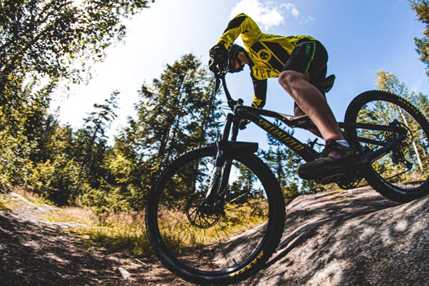
Santa Barbara offers a variety of mountain bike trails for riders of all skill levels. The Santa Ynez Mountains, located just outside of the city, provide challenging terrain for experienced riders with steep climbs and technical descents. The Jesusita Trail and Tunnel Trail are popular options in this area.
Beginner riders can enjoy the more gentle terrain of the Mission Canyon Trail and the Rattlesnake Canyon Trail. Santa Barbara’s mild climate makes it an ideal destination for year-round mountain biking.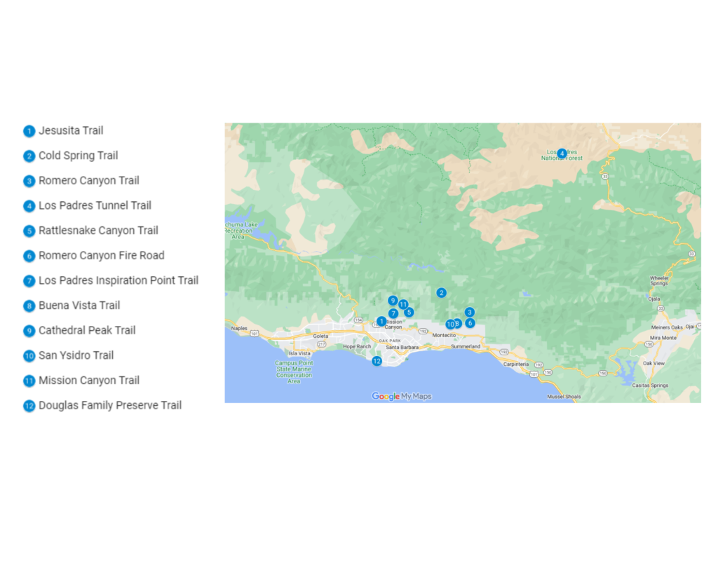
1. Jesusita Trail
The Jesusita Trail is an 8.5-mile out-and-back trail that offers a challenging and scenic ride through the foothills of the Santa Ynez Mountains. The trail starts at the top of Tunnel Road, and it offers a mix of technical sections and smooth fire roads.
The steep climbs and tight switchbacks make it a great workout for experienced riders, while the beautiful views of the Pacific Ocean and the Santa Barbara coastline make it a rewarding ride for all. As you ride through the chaparral and oak groves, you’ll reach a peak elevation of about 2,500 feet.
This trail is well-maintained and offers a variety of terrains, from rocky and steep to smooth and flowy. Along the way, you’ll enjoy stunning views of the Santa Barbara coastline, the Pacific Ocean, and even the city of Santa Barbara itself.
It’s important to note that the trail can get quite busy on weekends, so it’s best to plan your ride for a weekday if possible. Additionally, it is important to carry enough water as there are no water sources on the trail.
Overall, the Jesusita Trail is a must-ride for mountain bikers visiting Santa Barbara. Its challenging terrain and breathtaking views make it one of the best mountain biking experiences in the area. It’s a great way to explore the natural beauty of Santa Barbara and challenge yourself at the same time.
| Features | Description |
| Location | Jesusita Trail |
| Length of trail | 8.5 miles |
| Loop, out and back or point to point? | Point to Point |
| Level of difficulty | Easy/Intermediate |
| How much is paved | Singletrack |
| Average time to complete | 36 minutes |
| Stop-off points for food, water, restrooms | No |
2. Cold Spring Trail
Cold Spring Trail is a popular mountain biking trail in Santa Barbara, California, known for its scenic views and challenging terrain. The trail is approximately 6.5 miles out-and-back and offers a mix of technical sections and smooth fire roads.
The trailhead is located at the end of Cold Spring Road and takes you through a mix of chaparral and oak groves, with a peak elevation of about 2,800 feet. The trail offers challenging climbs and tight switchbacks, making it a great workout for experienced riders.
Along the way, you’ll enjoy stunning views of the Santa Barbara coastline, the Pacific Ocean, and even the city of Santa Barbara itself. This trail is more relaxed than others in Santa Barbara, making it a great option for a peaceful yet challenging ride.
| Features | Description |
| Location | Santa Barbara, California |
| Length of trail | 6.5 miles |
| Loop, out and back or point to point? | Loop |
| Level of difficulty | Easy/Intermediate |
| How much is paved | Singletrack |
| Average time to complete | 27 minutes |
| Stop-off points for food, water, restrooms | No |
3. Romero Canyon Trail
Romero Canyon Trail is a challenging and scenic mountain biking trail in Santa Barbara, California. The trail is approximately 4 miles out-and-back and offers a mix of technical sections and smooth fire roads.
The trailhead is located at the end of Romero Canyon Road and takes you through a mix of chaparral and oak groves, with a peak elevation of about 2,500 feet. The trail offers challenging climbs and tight switchbacks, making it a great workout for experienced riders.
Along the way, you’ll enjoy stunning views of the Santa Barbara coastline, the Pacific Ocean, and even the city of Santa Barbara itself. This trail is more relaxed than others in Santa Barbara, making it a great option for a peaceful and challenging ride.
| Features | Description |
| Location | Santa Barbara |
| Length of trail | 4 miles |
| Loop, out and back or point to point? | Loop |
| Level of difficulty | Easy/Intermediate |
| Terrain | 250m up 250m down |
| How much is paved | Singletrack |
| Average time to complete | 17 minutes |
| Stop-off points for food, water, restrooms | No |
4. Los Padres Tunnel Trail
The Los Padres Tunnel Trail is a challenging and picturesque mountain biking destination in Santa Barbara, California. The trail is approximately 4 miles in length and offers a mix of technical sections and smooth fire roads.
The trailhead is located at the top of Tunnel Road and takes you through a beautiful landscape of chaparral and oak groves, with a peak elevation of about 2,500 feet. The trail features challenging climbs and tight switchbacks, making it a great workout for experienced riders.
Along the way, you’ll be treated to breathtaking views of the Santa Barbara coastline, the Pacific Ocean, and even the city of Santa Barbara itself. The trail is less crowded compared to other trails in Santa Barbara, making it a nice, peaceful ride.
| Features | Description |
| Location | The Tunnel Trail |
| Length of trail | 4 miles |
| Loop, out and back or point to point? | Loop |
| Level of difficulty | Easy/Intermediate |
| Terrain | 250m Up & 250m Down |
| How much is paved | Singletrack |
| Average time to complete | 19 minutes |
| Stop-off points for food, water, restrooms | No |
5. Rattlesnake Canyon Trail
Rattlesnake Canyon Trail is a picturesque and challenging mountain biking trail in Santa Barbara, California. The trail, which is approximately 4 miles long, features a combination of technical sections and smooth fire roads.
The starting point of the trail is at the end of Rattlesnake Canyon Road. The trail takes you through a diverse landscape of chaparral and oak groves, reaching an elevation of around 2,500 feet. The challenging climbs and tight switchbacks make it a great workout for experienced riders.
Along the way, you can enjoy the beautiful views of the Santa Barbara coastline, the Pacific Ocean, and the town of Santa Barbara.
| Features | Description |
| Location | Rattlesnake Canyon |
| Length of trail | 4.3 miles |
| Loop, out and back or point to point? | Point to Point |
| Level of difficulty | Easy/Intermediate |
| Terrain | 261m Up & 253m Down |
| How much is paved | Singletrack |
| Average time to complete | 21 minutes |
| Stop-off points for food, water, restrooms | No |
6. Romero Canyon Fire Road
The Romero Canyon Fire Road bike trail is a must-ride for mountain bikers visiting Santa Barbara, California. This challenging trail offers stunning views of the Pacific Ocean and the Santa Ynez Mountains as it winds its way through the Romero Canyon.
The trail is well-maintained, with a combination of single track and fire road sections that are suitable for intermediate to advanced riders. The climb to the top of the canyon is steep, but the descent is well worth the effort.
Be sure to bring plenty of water, as there is little shade on the trail. Overall, the Romero Canyon Fire Road bike trail is an excellent choice for those looking for a scenic and challenging ride in the Santa Barbara area.
| Features | Description |
| Location | Romero Canyon Fire Road |
| Length of trail | 7 miles |
| Loop, out and back or point to point? | Loop |
| Level of difficulty | Easy/Intermediate |
| How much is paved | Singletrack |
| Average time to complete | 30 minutes |
| Stop-off points for food, water, restrooms | Yes, portable toilets are available on route |
7. Los Padres Inspiration Point Trail
The Los Padres Inspiration Point bike trail is a must-ride for mountain bikers visiting Santa Barbara, California. This challenging trail offers stunning views of the Pacific Ocean and the Santa Barbara coastline as it winds its way up to the summit of Inspiration Point.
The trail is well-maintained, with a combination of single track and fire road sections that are suitable for intermediate to advanced riders. The climb to the top of the summit is steep, but the descent is well worth the effort. The trail is 2.5 miles round trip and has an elevation gain of about 600 feet.
Be sure to bring plenty of water and protective gear, as there is little shade on the trail. Overall, the Inspiration Point bike trail is an excellent choice for those looking for a scenic and challenging ride in the Santa Barbara area.
| Features | Description |
| Location | Inspiration Point |
| Length of trail | 2.5 miles |
| Loop, out and back or point to point? | Loop |
| Level of difficulty | Easy/Intermediate |
| Terrain | 60m Up & 60m Down |
| How much is paved | Singletrack |
| Average time to complete | 11 minutes |
| Stop-off points for food, water, restrooms | Yes, portable toilets are available on route |
8. Buena Vista Trail
The Buena Vista bike trail is a must-ride for mountain bikers visiting the Los Angeles area. This challenging trail offers stunning views of the San Gabriel Mountains as it winds its way through the Buena Vista Canyon.
The trail is well-maintained, with a combination of technical single-track and fire road sections that are suitable for intermediate to advanced riders. The climb is steep, and the descent is fast, with some rocky and loose sections. The trail is about 4 miles long. Be sure to bring plenty of water and protective gear, as there is little shade on the trail.
Overall, the Buena Vista bike trail is an excellent choice for those looking for a scenic and challenging ride in the Los Angeles area. It’s a great way to explore the natural beauty of the San Gabriel Mountains while getting a workout.
| Features | Description |
| Location | Buena Vista |
| Length of trail | 4 miles |
| Loop, out and back or point to point? | Point to Point |
| Level of difficulty | Easy/Intermediate |
| How much is paved | Singletrack |
| Average time to complete | 23 minutes |
| Stop-off points for food, water, restrooms | No |
9. Cathedral Peak Trail
Located in the Tuolumne Meadows area of Yosemite National Park, the Cathedral Peak bike trail is a must-do for intermediate to advanced mountain bikers. The 10-mile trail offers stunning views of Cathedral Peak and the surrounding mountains as it winds through challenging high-elevation terrain.
Expect a steep climb, fast descent, and some rocky and loose sections. Be sure to bring plenty of water and protective gear, as shade is limited on the trail. The trail is well-maintained and is a great way to explore the natural beauty of the High Sierra while getting a workout.
If you’re looking for a scenic and challenging ride, the Cathedral Peak bike trail is an excellent choice.
| Features | Description |
| Location | Yosemite National Park |
| Length of trail | 10 miles |
| Loop, out and back or point to point? | Loop |
| Level of difficulty | Easy/Intermediate |
| Terrain | 291m Up & 291m Down |
| How much is paved | Singletrack |
| Average time to complete | 42 minutes |
| Stop-off points for food, water, restrooms | No |
10. San Ysidro Trail
For mountain bikers seeking a challenging and scenic ride in the Santa Barbara area, the San Ysidro bike trail is another great option. The 7-mile trail winds through the beautiful San Ysidro Canyon, offering views of the Pacific Ocean and the Santa Ynez Mountains.
Expect a mix of technical single-track and fire road sections, a steep climb, fast descent, and some rocky and loose sections. Be sure to bring plenty of water and protective gear, as shade is limited on the trail.
The trail is well-maintained and offers an excellent workout while enjoying the natural beauty of the Santa Barbara area. It is suitable for intermediate to advanced riders.
| Features | Description |
| Location | San Ysidro |
| Length of trail | 7 miles |
| Loop, out and back or point to point? | Loop |
| Level of difficulty | Easy/Intermediate |
| How much is paved | Singletrack |
| Average time to complete | 30 minutes |
| Stop-off points for food, water, restrooms | No |
11. Mission Canyon Trail
The Mission Canyon bike trail is a must-ride for intermediate to advanced mountain bikers. This 8-mile trail offers beautiful views of the Santa Barbara Mission and the surrounding mountains as it winds through the Mission Canyon.
Expect a mix of technical single-track and fire road sections, a steep climb, fast descent, and some rocky and loose sections. Be sure to bring plenty of water and protective gear, as shade is limited on the trail.
The trail is well-maintained and offers an excellent workout while enjoying the natural beauty of the area, including the historical Santa Barbara Mission. It is an excellent choice for those looking for a challenging and scenic ride in the Santa Barbara area.
| Features | Description |
| Location | Mission Canyon |
| Length of trail | 8 mile |
| Loop, out and back or point to point? | Point to Point |
| Level of difficulty | Easy/Intermediate |
| Terrain | 152m Up & 152m Down |
| How much is paved | Singletrack |
| Average time to complete | 37 minutes |
| Stop-off points for food, water, restrooms | No |
12. Douglas Family Preserve Trail
The Douglas Family Preserve bike trail is ideal for intermediate to advanced mountain bikers. This 5-mile trail offers spectacular views of the Pacific Ocean, the Santa Ynez Mountains, and the surrounding natural beauty as it winds through the protected and preserved Douglas Family Preserve.
Expect a mix of technical single-track and fire road sections, a challenging climb, fast descent, and some rocky and loose sections. The trail is well-maintained but remember to bring plenty of water and protective gear, as there is limited shade on the trail.
This trail is an excellent choice for those who want to experience the natural beauty of Santa Barbara while getting a good workout.
| Features | Description |
| Location | Douglas Family Preserve |
| Length of trail | 5 miles |
| Loop, out and back or point to point? | Loop |
| Level of difficulty | Easy/Intermediate |
| How much is paved | Singletrack |
| Average time to complete | 25 minutes |
| Stop-off points for food, water, restrooms | Yes, portable toilets are available on route |
Conclusion
Santa Barbara offers a diverse range of mountain biking trails that cater to riders of all skill levels. From the technical singletrack of the Jesusita and Tunnel trails to the more relaxed and scenic routes of the Romero and Jesusita Canyon trails, there is something for everyone.
The beautiful scenery, mild climate, and well-maintained trails make Santa Barbara a top destination for mountain biking enthusiasts. With so many options to choose from, it’s easy to see why Santa Barbara is considered a premier spot for mountain biking in Southern California.