The twin cities of Minneapolis and Saint Paul are absolutely loaded with bike trails, most of which are very family-friendly and invite you to explore the metro area and its surroundings in a healthy, fun and pleasurable way.
One of the best features of most of the bike rides is that they pass through green, natural areas which can be found in parks and on regional and state bike trails along rivers and lakes so characteristic of the Twin Cities. Trails like the Midtown Greenway and Northern Greenway in Minneapolis are close enough to the city-wide services available yet feel as if they are somewhere else. Most of the trails are broad, multi-purpose paved bike lanes that are used by walkers, runners, bikers and rollers.
During the warmer months, they’re filled and lined with runners and bikers. When the lakes freeze and snow lines the paths and trails, the most dedicated bikers switch to using studded tires and keep cycling whatever the weather.
Here is a selection of some of the Twin Cities’ best bike trails, but don’t forget both Minneapolis and St. Paul have many more paths and trails for you to explore! Enjoy!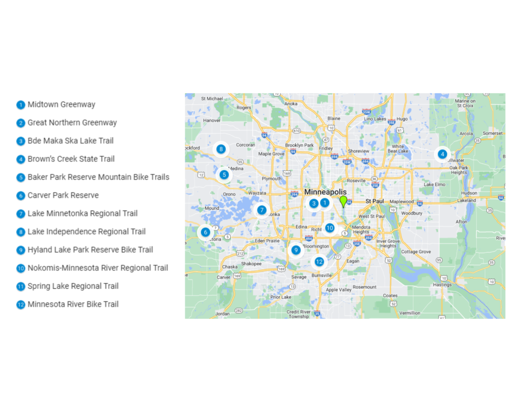
1. The Midtown Greenway
The Midtown Greenway is an enormously popular and well-used biker highway that cuts across the metro area of South Minneapolis affording a magnificent facility for commuters who choose to travel by bike as well as a leisure opportunity for individuals and families.
The Midtown Greenway is also a hub that connects with other Twin City state trails from the Chain of Lakes to the Southwest LTR Trail. The trail uses an old railroad corridor and although it cuts through the heart of South Minneapolis it is actually a scenic gem that remains visually separate from its urban surroundings.
The Greenway is lit 24/7 and during winter snow it is regularly plowed. This means that it can be used whatever the weather. During summer it is used daily by thousands of runners, walkers and bikers, but even in the heart of winter, it is still a popular route used by the hardiest of bikers.
The development of the Greenway was due to community persuasion in the form of the Midtown Greenway Coalition, which is still influential in advising of upgrades in the future. The City of Minneapolis is responsible for its maintenance.
| Feature | Description |
| Location | South Minneapolis |
| Trail length | 5.5 miles |
| Loop, out and back or point to point | Point to point from the Chain of Lakes to the Southwest LTR. |
| Level of difficulty | Easy riding all the way. |
| Terrain | Paved broad path lit at night and plowed in winter. |
| Grade of track | Mostly flat. |
| Average time to complete | Allow up to an hour. |
| Stop-off points for refreshments/water and other facilities | Runs parallel to a major Minneapolis thoroughfare with all retail services available. |
2. The Great Northern Greenway
This is the northern counterpart to the Midtown Greenway and connects the North and Northeast of Minneapolis along a wide asphalt multi-use bike path that is fully lit and plowed in winter so that it can be used 24/7 all year.
The Great Northern Greenway links the diverse neighborhoods of northern Minneapolis from historic residential districts and the West Broadway Business District to riverside post-industrial development and the Northeast Arts District. The Greenway will hopefully soon see a new bridge crossing over the Mississippi River which has yet to be determined whether it will follow the existing railroad bridge or not. The Northeast section is also soon to see completed sections so that the Arts District can be enjoyed at all times of the year with access to festivals,
Like the Midtown Greenway, the Northern Greenway is for all non-motorized traffic, including walkers, runners, joggers, skaters, and, of course, bikers!
| Feature | Description |
| Location | North Minneapolis |
| Trail length | 5 miles. |
| Loop, out and back or point to point | Point to point connecting Theodore Wirth Parkway and New Brighton Boulevard. |
| Level of difficulty | Easy riding. |
| Terrain | Two lane asphalt bike path. |
| Grade of track | Mostly flat. |
| Average time to complete | Up to an hour. |
| Stop off points for refreshments/water and other facilities | Passes close to all urban services including cafes, restaurants and parks. |
3. The Bde Maka Ska Lake Trail
Bde Maka Ska Lake is just one of the many lakes in the “Chain of Lakes” on the western side of downtown Minneapolis and to the east of St. Louis Park. The Bde Maka Ska Lake trail is a circular bike ride around the lake enjoyed by pedestrians, runners and joggers, horse riders and bikers.
The bike trail is in a metro area setting but by the side of the lake. The bike lanes pass right by the Baken Museum and attractive residential neighborhoods in the Uptown part of the city.
The lake is very popular in summer and on weekends so there can be some congestion but this is alleviated somewhat with a separate marked path for those on bikes.
| Feature | Description |
| Location | Chain of Lakes, Minneapolis |
| Trail length | 3.2 miles |
| Loop, out and back or point to point | A loop around Bde Maka Ska Lake |
| Level of difficulty | Easy/ Beginner. |
| Terrain | Two lane asphalt bike path. |
| Grade of track | Mostly flat. |
| Average time to complete | Take up to an hour. |
| Stop-off points for refreshments/water and other facilities | Restrooms and water available in the park. |
4. Brown’s Creek State Trail
This trail is a connecting trail between the St. Croix National Scenic Riverway in Stillwater and the Gateway State Trail in Grant. Because the trail follows an old disused, railroad track, it is mostly level and accessible to all types of bikers, including mountain bikers.
Like a lot of other Twin Cities bike trails, part of the Brown’s Creek State Trail is immersed in nature. This bike ride follows the St. Croix River for a mile with amazing views over the National Scenic Riverway. The St. Croix River is the only river in Minnesota which is part of the Wild and Scenic Rivers system, a federal classification.
Two miles of the trail also follows Brown’s Creek which is surrounded on both sides by a dense cover of broadleaf forest and is a recognized trout stream.
A number of community and state associations and organizations made the acquisition and development of this beautiful trail possible. Apart from bikers, the trail is open to all non-motorized users with some restrictions for horse riders.
| Feature | Description |
| Location | Stillwater |
| Trail length | 5.9 miles. |
| Loop, out and back or point to point | Point to point. |
| Level of difficulty | Easy. |
| Terrain | Asphalted 2 lane bike path. |
| Grade of track | Flat ride. |
| Average time to complete | Allow up to an hour. |
| Stop-off points for refreshments/water or other facilities | Restrooms and water in parks along trail. |
5. Baker Park Reserve Mountain Bike Trails
For the more adventurous mountain bikers in the Twin Cities there are several places where you can roar up and down and round and round on some of the area’s well-designed and maintained mountain bike trails. One of these places is Baker Park Reserve in Medina, a popular state regional park.
The 12.5 miles of the Baker Park Reserve mountain bike paths are well-suited for beginner mountain biker and expert alike. There is also a more sedate paved bike path available for families with small children, which links up with the wider Twin Cities bike trail system.
The park is on the banks of a very scenic Minnesota lake – Lake Independence – and has 2,700 acres of space where you can do almost anything you want in the great outdoors. Apart from the bike trails, there is camping (in summer), golfing and cross-country skiing (in winter). There is always something for everyone at Baker Park!
| Feature | Description |
| Location | Baker Park Reserve, Lake Independence, Maple Plain, MN |
| Trail length | 12.5 miles |
| Loop, out and back or point to point | Series of off-road loop and one way trails |
| Level of difficulty | Intermediate |
| Terrain | Off road aggregate |
| Grade of track | Flat |
| Average time to complete | Depends on trail chosen. Could spend all day here! |
| Stop-off points for refreshments/water and other facilities | Restrooms and water available in Baker Park. |
6. Carver Park Reserve Bike Trail
Carver Park Reserve, another one of the state’s regional parks, has over 9 miles of well-maintained bike trails in a stunning, natural landscape on the western edge of the Twin Cities accessible along a county road. The trail network consists of a short section of paved trails and a longer section of unpaved trail. The paved section passes through a pretty, wooded area, while the unpaved section passes through more of a prairie landscape. The Carver Park Reserve Bike Trail also connects to the Lake Minnetonka Regional Trail and the campground at Lake Auburn.
The main bike path traces a loop around the edges of the park, but you can cut corners using the connecting trail in the central part of the park. Much of the trail passes through big woods and marshes as well as the prairie section.
Carver Park Reserve is where you can find the Grimm Farm Historic Site, the Lowry Nature Center and the King Waterbird Sanctuary. There is plenty of wildlife in the woods and marshes like white-tailed deer, ospreys, swans, mink, barred owls and many other water birds and songbirds.
| Feature | Description |
| Location | Waconia at western edge of the Twin Cities |
| Trail length | 9.1 miles. |
| Loop, out and back or point to point | Loop trail with central connector. |
| Level of difficulty | Easy / Beginner. |
| Terrain | Paved path. |
| Grade of trail | Flat. |
| Average time to complete | Allow up to an hour and a half. |
| Stop-off points for refreshments/water and other facilities | Restrooms and water available in the park. |
7. Lake Minnetonka Regional Trail
The Lake Minnetonka Regional Trail stretches for more than 15 miles between Carver Park Reserve and Hopkins and passes the small towns of Victoria, Shorewood, Excelsior, Greenwood, Deephaven and Minnetonka which means that there is always somewhere you can deviate off to have a coffee or a break while you ride the trail.
The main trail is very well maintained and can be ridden whatever your level of experience, but there are loop trails that connect with the main trail that allow more experienced riders to experience fun on more challenging rides.
Most of the surface is aggregate, so mountain bikers will be happy tackling this bike ride which runs along the side of the lake and through wooded sections and open farm fields.
If you want to extend your time in this area and have camping gear, you can camp for a night or two at Carver Park reserve at one end of the bike ride or use it to connect up with the main Twin Cities state trail network for a longer trip.
| Feature | Description |
| Location | Excelsior. Links Hopkins and Carver Park Reserve. |
| Trail length | 15.8 miles. |
| Loop, out and back or point to point | Point to point. |
| Level of difficulty | Main trail is easy. Side trails for more experienced bikers. |
| Terrain | Aggregate surface. |
| Grade of track | Flat. |
| Average time to complete | Allow up to 2 to 3 hours but varies depending on how much is ridden. |
| Stop-off points for refreshments/water or other facilities | Restrooms and water available along the trail in parks. |
8. Lake Independence Regional Trail
The Lake Independence Regional Trail connects the Crow-Hassan Park Reserve west of downtown Minneapolis in the community of Hanover to 6th Avenue North. There are several options that allow the bike rider to connect to other sections of the main Twin Cities state trail network such as Orono’s Luce Line State Trail.
The trail meanders its way between Lakes Katrina and Independence and then edges its way around the Baker Park Reserve with its own loop trail. There are plenty of great views of lakes, wooded foothills and marshes. The main parking area if you don’t rise from the city is at Crow-Hassan Park Reserve at Park Drive. The entrance is on CR 19 at the recreation area there.
| Feature | Description |
| Location | Crow-Hassan Park Reserve, Hanover. |
| Trail length | 15.9 miles. |
| Loop, out and back or point to point | Mostly point to point with an optional loop around Lake Baker. |
| Level of difficulty | Easy. |
| Terrain | Asphalt path. |
| Grade of track | Flat. |
| Average time to complete | Allow 1 to 2 hours. |
| Stop-off points for refreshments/water or other facilities | Restrooms at Crow-Hassan Park Reserve and at most small towns en route. |
9. The Hyland Lake Park Reserve Bike Trail
When you want more of a workout on your mountain bike, head to Hyland Park Reserve. The bike rides here are hillier than most other bike paths around the Twin Cities and offer an exhilarating experience up and down the trail’s hills and winding around tight corners.
The Hyland Lake Park Reserve Bike Trail is well maintained and consists of a mixture of paved paths and gravel trails amongst trees and hills.
The trail is mostly used by bikers in summer and is then switched over to a ski run in winter. A good indication of the terrain is the fact that the last stretch of the bike trail is a popular downhill ski run in winter!
The whole trail is very scenic even though it isn’t particularly lengthy. Hyland Park Reserve is a popular place for families at all times of the year, particularly in summer when the lake is used for kayaking and canoeing – non-motorized craft only. There is a camping area in the reserve as well.
| Feature | Description |
| Location | Bloomington. |
| Trail length | 8.6 miles. |
| Loop, out and back or point to point | Series of loops. |
| Level of difficulty | Intermediate |
| Terrain | Mixture of paved and dirt sections. |
| Grade of track | Some undulating sections through rolling hills |
| Average time to complete | Allow up to an hour and a half. |
| Stop-off points for refreshments/water and other facilities | Restrooms and water in the park reserve. |
10. Nokomis-Minnesota River Regional Trail
The Nokomis-Minnesota River Regional Trail consists of a series of loops which offer something for every category of biker. Some of the loops are quite challenging, but the main trail is accessible to any level of experience and is well-maintained and paved.
The trail passes through the main center of Richfield as it deviates from the southern shore of Lake Nokomis. The trail is still in the process of development as its 5 current miles are expected to be extended to seven miles and will eventually connect with the Minneapolis Grand Rounds Scenic Byway System and the Nine Mile Creek Regional Trail. The trail passes through residential neighborhoods and commercial areas as well as Bloomington’s famous Mall of America.
| Feature | Description |
| Location | Lake Nokomis Parkway to 86th St. & Old Cedar Ave. |
| Trail length | 7 miles. |
| Loop, out and back or point to point | Point to point. |
| Level of difficulty | Beginner / easy. |
| Terrain | Paved 8 foot wide path |
| Grade of track | Flat. |
| Average time to complete | Allow up to an hour. |
| Stop-off points for refreshments/water and other facilities | Close to all urban services. |
11. Spring Lake Regional Trail
Spring Lake Regional Trail is quite short, at only 3 miles long, but makes up for its length with its natural splendor. It passes through some of the last great wooded areas of Scott County and the whole ride has very pleasant lush green scenery. This bike path is not plowed in winter so is more of an April to October experience for all but the most enthusiastic bike riders.
Spring Lake Regional Park is very diverse where there is plenty of wildlife amongst the 374 acres of habitat. There is a small creek, old-growth maple forest, cattail marshes, open-water wetlands and a tamarack bog. You can see eagles soar and swoop as you ride the trail. Like most Twin Cities state trails, you can connect with other bike rides in the network like the Scott West Regional Trail. Take this trail to reach Cleary Lake Regional Park or Downtown Prior Lake.
| Feature | Description |
| Location | Prior Lake. |
| Trail length | 3 miles. |
| Loop, out and back or point to point | Loop trail. |
| Level of difficulty | Beginner / easy. |
| Terrain | Paved path. |
| Grade of track | Flat. |
| Average time to complete | Half an hour. |
| Stop-off points for refreshments/water and other facilities | Restrooms and water available in the park. |
12. Minnesota River Bike Trail
The 11 miles of the Minnesota River Bike Trail lie wholly within the flood plain of the Minnesota River. It’s not just reserved for bikers as the River “Bottoms” attract hikers, dog walkers, bird watchers and trail runners.
The trail is continually subject to change depending on the vagaries of the Minnesota River, so you do need to anticipate obstacles after heavier rain. Expect some quite technical sections and at the same time, you have to watch out for other trail users. In addition, some of the main trail is quite sandy. On winter Saturdays, the trail attracts fat bikes and there are sometimes large gatherings of fat bike riders on what they call “Faturday” rides.
The Minnesota River Bike Trail is part of a much longer (72 miles) state trail corridor which snakes along the river between Le Sueur and Fort Snelling State Park.
| Feature | Description |
| Location | Bloomington. |
| Trail length | 11 miles. |
| Loop, out and back or point to point | Linear trail. |
| Level of difficulty | Intermediate and technical in places. |
| Terrain | Sandy / gravel. |
| Grade of track | Flat. |
| Average time to complete | 1 to 1 and a half hour. |
| Stop-off points for refreshments/water and other facilities | Restrooms and water available along the trail. |