Williamsburg is probably better known for its colonial history than for its bicycle trails but what better way of seeing all the sights around Williamsburg than leaving your car behind. Enjoy the excellent variety of bike lanes and multi-use trails that abound in and around Williamsburg and in fact all the way from Jamestown and the James River to the site of the Yorktown battlefield. The slower you travel, the more you see!
Williamsburg’s bike trails have something for everyone. There are the 23 miles of the Colonial Parkway that winds its way between Jamestown and Yorktown and the longer Capital Trail that links the old, original, colonial capital city of Jamestown to the current Virginia capital of Richmond.
For families and individuals who just want to see some of Williamsburg’s lovingly restored colonial historical landmarks, there is a plethora of well-designed shorter trails. Colonial Williamsburg is probably Williamsburg’s better-known attraction, but you can use your bike to see the Chickahominy Riverfront Park, the York River state park, the Powhatan Creek Trail and the Yorktown Battlefield without too much exertion. There are plenty of access points and parking lots that allow you to offload your bike and join a trail while enjoying all the comforts and services available in a well-resourced urban environment.
Then, for avid cyclists and MTB fans there are miles of mountain bike trails that wind in and around wooded areas and pine forests. Contact one of Williamsburg’s enthusiastic biking associations to discover more about where you can mountain bike around Williamsburg like the Eastern Virginia mountain bike association.
The 12 best bike trails described below are just a taste of what Williamsburg has to offer.
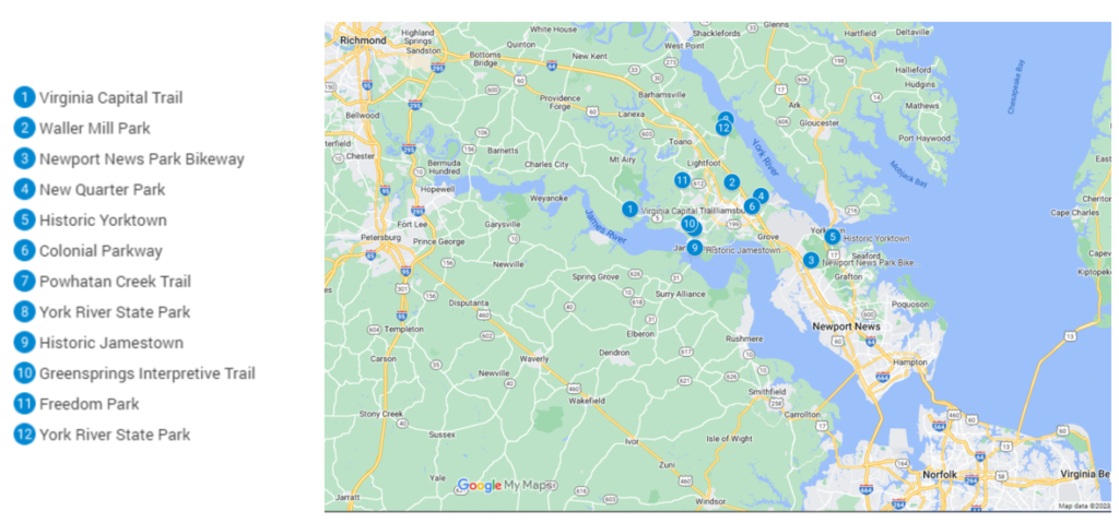
1. Virginia Capital Trail
The Virginia Capital Trail is the longest multi-use trail in the Williamsburg area and is deservedly popular as it links the historic centers of Jamestown Settlement, Virginia’s oldest capital, and the modern state capital of Richmond.
The trail is 52 miles long and parallels Scenic Route 5, so allows access at numerous points along its length. Construction on the trail started in 2005 and now sees over a million users every year. There are plans to extend the trail with connections to other trails in the near future. The trail boasts multiple attractions, including historic sites, natural features, the James River and rolling countryside.
The Capital Trail is divided into seven well-signposted sections for easy navigation and is mostly paved although there are some short, wooden boardwalks along the way. There are plenty of places along the way to access restrooms, refreshments and other amenities.
| Feature | Description |
| Location | Can be accessed anywhere along its length. |
| Trail length | 51.7 miles. |
| Loop, out and back or point to point | Jamestown to Richmond. |
| Level of difficulty | Easy. |
| Terrain | Mostly paved with some boardwalk sections. |
| Grade of track | Mostly flat. |
| Average time to complete | 4-6 hours. |
| Stop off points for refreshments/water and other facilities | Refreshments, water and rest rooms available at points along the bike trail. |
2. Waller Mill Park
Waller Miller Park, in Williamsburg, is the site of a beautiful, 4-mile-long multi-use trail that you can use if you have a road bike, a mountain bike, walk or run. You can take your dog for a run, here, too, but it must be on a leash. It’s open year-round and is lovely whatever the time of the year.
There is only one steep section and the trail is completely paved and wide so is a trail for beginners as well as those who just like to ride through nature.
The parking area to access the trail is not at one end of the trail, so you can decide to go in either direction, bike in both directions, and then return to your car. There is a lookout at one point along the trail with views over the Waller Miller Reservoir and picnic benches close by so you can take your time and enjoy a few hours in this part of the park.
| Feature | Description |
| Location | Waller Miller Park, Williamsburg. |
| Trail length | 4 miles |
| Loop, out and back or point to point | Out and back. |
| Level of difficulty | Easy. |
| Terrain | Smooth, asphalt surface. |
| Grade of track | Mostly gentle with only one steep downhill section. |
| Average time to complete | 1 hour and 10 minutes. |
| Stop off points for refreshments/water and other facilities | Restrooms and picnic tables in Waller Miller Park. |
3. Newport News Park Bikeway
The Newport News Park Bikeway is a loop bike path through the 8,000-acre park. It is connected to the Colonial National Historical Park so you can deviate off from the bike trail to have a look at the Yorktown Battlefield and George Washington’s headquarters nearby.
Most of the bike path is easy to use and some people choose to do two loops, biking in different directions to catch a varied view of the woodlands and natural features along the way. The parking area is along Jefferson Avenue, Newport News, off Interstate 64, Exit 250B.
Some visitors to Williamsburg who have bikes stay at the campsite in Newport News and are then close to the bike trail and its connections to historical features nearby. It’s great for beginner cyclists as the path is wide and flat.
| Feature | Description |
| Location | Newport News Park, Jefferson Avenue. |
| Trail length | 5 miles. |
| Loop, out and back or point to point | 6 foot wide loop. |
| Level of difficulty | Easy. |
| Terrain | Dirt track. |
| Grade of track | Flat. |
| Average time to complete | 40 minutes. |
| Stop off points for refreshments/water and other facilities | Easy access from campsite in the park. |
4. New Quarter Park
The Eastern Virginia Mountainbike Association has built and maintains this 5.8 mile loop in New Quarter Park, specifically designed for more experienced mountain bikers and generally for more experienced bikers. Like a lot of trails in and around Williamsburg, the trail passes close by many points of historical interest, although most users will probably be hanging on top of the tight turns and many ups and downs to spend much time deviating off along the way. For history buffs, note the Civil War dugouts along the first mile of the trail as the first part of the trail lies along the Confederate Defensive Line.
Whether you are ascending or descending, you won’t find many flat sections on this trail! There are also ravines and tight corners to negotiate, but there isn’t anything especially dangerous. Like a lot of mountain bike trails, the more you use it, the better you will get!
| Feature | Description |
| Location | New Quarter Park. |
| Trail length | 5.8 miles. |
| Loop, out and back or point to point | Single loop. |
| Level of difficulty | Intermediate. |
| Terrain | Dirt track. |
| Grade of track | Undulating with some steep, hilly sections. |
| Average time to complete | 1 to 1 and a half hour. |
| Stop off points for refreshments/water and other facilities | New Quarter Park has water and rest rooms. |
5. Historic Yorktown
The historic part of Yorktown has two multi-use tour routes which you can use if you are on a bike, decide to walk or use your own vehicle. Biking either of the two designated routes is probably the best way of getting around this fascinating, historic settlement as you can stop and start just as you want without worrying about parking. At the same time, you can cover more ground than if you just walk the paths.
Each touring route is well signposted with color coding. The shorter Battlefield Tour is marked by red arrows, while the longer Encampment Tour is marked by yellow arrows. The Encampment Tour is less frequented by motorized vehicles, so is the pleasanter of the two routes for those on bikes. Vehicles are prohibited from using Main Street in Yorktown between Spring and Fall, and bikers must dismount as they cross the Tobacco Road footbridge.
| Feature | Description |
| Location | Yorktown. |
| Trail length | 5 to 10 miles depending on the use of extensions. |
| Loop, out and back or point to point | Point to point along the York River with side extensions. |
| Level of difficulty | Easy. Multi-use so expect pedestrians and motorized vehicles. |
| Terrain | Paved. |
| Grade of track | Flat. |
| Average time to complete | 1 to 2 hours. |
| Stop off points for refreshments/water and other facilities | Refreshments and restrooms available along either route. |
6. Colonial Parkway
The Colonial Parkway is the second longest multi-use bike path in the Williamsburg area at nearly 23 miles and is open all year round. You don’t need a mountain bike for this bike path because it has been so well built that it can be used by road bikes as well as walkers, joggers, horse riders and skaters.
It can take the whole day to complete the whole path depending on just how much you know the attractions along the way and decide to deviate. Refreshments in the form of meals, snacks and drinks can be purchased at several locations so this is a route that you can use to enjoy the day biking in either direction from Williamsburg without having to take anything with you. There are even wineries along the way to sample some of Virginia’s unique winemakers as well as craft breweries like the Billsburg Brewery near the Jamestown Settlement.
| Feature | Description |
| Location | Bike trail linking Jamestown, Williamsburg and Yorktown. |
| Trail length | 23 miles. |
| Loop, out and back or point to point | Point to point or out and back from Williamsburg to Jamestown or Yorktown separately. |
| Level of difficulty | Easy. |
| Terrain | Asphalt. |
| Grade of track | Flat. |
| Average time to complete | 1 to 2 days. |
| Stop off points for refreshments/water and other facilities | Refreshments, cafes, a winery and rest rooms along the Parkway and in the settlements. |
7. Powhatan Creek Trail
If you want to see a shorter section of the Virginia Capital Trail but a really nice part, you can do no better than bike the Powhatan Creek Trail. It’s only just over 2 miles long, but if you want to extend your time cycling, you can do so easily by connecting up with the Greensprings Interpretive Trail or the Virginia Capital Trail itself.
The highlight of the Powhatan Creek Trail must be the 696-foot-long bridge across the Powhatan Creek, built entirely of timber. As you cycle across the bridge, listen to the sounds of the creek streaming past underneath you. This bridge is just one of several bridges you cross as you make your way along the trail.
The Powhatan Creek Trail is open from dawn to dusk all year round and is dog-friendly, so you can take your pooch for a run while you ride the trail!
| Feature | Description |
| Location | Parking at Clara Byrd Baker Elementary School. |
| Trail length | 2 miles. |
| Loop, out and back or point to point | Point to point or out and back. |
| Level of difficulty | Easy. |
| Terrain | Asphalt. |
| Grade of track | Flat. |
| Average time to complete | 30 minutes. |
| Stop-off points for refreshments/water and other facilities | Facilities available at Jamestown. |
8. York River State Park
Many of the bike paths and trails in the Williamsburg area are designed for pleasant cycling by all types of bikers, and most are multi-use. However, enthusiastic mountain bikers are not forgotten as there are several more exciting mountain bike trails close to Williamsburg like the trails in the York River State Park. Don’t expect manicured asphalt paths and boutique cafes and coffee houses as the mainly one-way trails are on dirt, and can be challenging, especially if there has been recent rain.
Like many mountain bike trail networks, the more you frequent the trails, the easier you will find the navigation and the more daring you will become. Most regular York River State Park riders will use an app to find their way around and connect from one trail to another, meaning that you can spend several hours here or just a short time depending on your other commitments. Note that some of the trails in the state park are reserved for hikers only, so check your route before you start off.
| Feature | Description |
| Location | York River State Park. |
| Trail length | Varies from very short to 12-mile trails. |
| Loop, out and back or point to point | Mostly single-direction trails. |
| Level of difficulty | Mostly intermediate/experienced mountain bikers. |
| Terrain | Dirt. |
| Grade of track | Mostly undulating with some steep, hilly sections. |
| Average time to complete | Depends on number of trails used. Could spend all day here! |
| Stop-off points for refreshments/water and other facilities | No facilities on trails. Take water with you and use restrooms before biking. |
9. Historic Jamestown Bike Trail 3- or 5-mile loop
The two historic Jamestown Bike Trail loops are a fantastic safe way for you and your family to see the sights of Jamestown Island. The trails are multi-use and are used not just by bikers, but by walkers and motorized vehicles, too, but the latter is restricted to a strict 15 mph speed limit, making cycling a safe and attractive alternative.
The shorter of the two available loops is only 3 miles long, while the longer one is 5 miles long, providing a choice of doing both loops in one hit or cycling each loop separately on different days, remembering that there are plenty of things to see on either loop to entertain and inform you of one of North America’s oldest colonial settlements.
The island itself is not just a historical site but has much natural interest, too. There are regenerating woodlands and marshlands with lovely scenery and interesting wildlife to look out for as you ride the well-maintained trails.
| Feature | Description |
| Location | Historic Jamestown on Jamestown Island. |
| Trail length | Two loops of 3 and 5 miles each. |
| Loop, out and back or point to point | Loop trails. |
| Level of difficulty | Easy. |
| Terrain | Paved. |
| Grade of track | Flat. |
| Average time to complete | Allow up to 2 hours depending on stopovers for sights along each route. |
| Stop-off points for refreshments/water and other facilities | Refreshments and restrooms on both loops. |
10. Greensprings Greenway Interpretive Trail
The Greensprings Interpretive Trail is a different type of bike trail that appeals to nature lovers especially. While it has been included here as a bike trail, it can be used by walkers as well and you can take your dog as long as it is on a leash.
The trail is only 3.5 miles in length, but there are plenty of natural features to look out for as the trail weaves its way through woodlands, marshes, beaver ponds and forests. The reason for its name becomes immediately obvious as there are plenty of interpretive signs along its length detailing features of the trail’s nature and old, colonial history as well as descriptions of life led by the original inhabitants of this area before settlement by the British.
The trail is part of the longer Virginia Birding Trail and an amazing 200 species of birds have been spotted in this area, so take your binoculars and bird guide app if you are a keen birder.
| Feature | Description |
| Location | 3751 John Tyler Highway, Williamsburg. |
| Trail length | 3.5 miles. |
| Loop, out and back or point to point | Out and back. |
| Level of difficulty | Easy. |
| Terrain | Dirt track. |
| Grade of track | Gently undulating. |
| Average time to complete | 40 minutes to 1 hour. |
| Stop-off points for refreshments/water and other facilities | None on trail. |
11. Freedom Park multiple trails
Freedom Park is the site of a number of exciting mountain bike trails for the MTB enthusiast. Most of these trails intersect at some point, so you can ride the trails all day or select a single trail or two for a shorter experience. There is one loop trail that is suitable for beginner mountain bike riders, the Bunny Trail, but most are not suitable for beginners as there are frequent twists and turns as well as steep uphill and downhill sections.
Like most mountain bike trails, the more you use the trails the more familiar you will be and the better your experience. Take a map or a bike trail app while you are a newbie in this area to help with navigation.
The park is not just a place for bike riders. There is a botanical garden, a museum, a park office, a meeting room and restrooms so there is something for everyone at Freedom Park!
| Feature | Description |
| Location | Freedom Park, 5537 Centerville Rd, Williamsburg. |
| Trail length | Up to 20 miles of trails. |
| Loop, out and back or point to point | Mostly one-way trails with interconnections. Map useful for navigation. |
| Level of difficulty | Intermediate, except for the easy / beginner Bunny Loop. |
| Terrain | Dirt. |
| Grade of track | Bumps, mounds, bridges and hills. |
| Average time to complete | 30 minutes to several hours. |
| Stop-off points for refreshments/water and other facilities | No facilities on trails. Restrooms and water are available in the park. |
12. John Blair Mountain Bike Trail
The John Blair Trail is the longest of the York River Park trails that have already been highlighted above. It is an almost 10-mile single-track bike trail that is designed for experienced mountain bikers. The trail begins and ends in different parts of the park, but because it connects with other trails, can be extended to get back to the starting point without too much difficulty.
The trail has been signposted so you can navigate your way more easily with seven separate sections. The last section terminates at the Pamunkey Trail and is most easily accessed at the Bobcat Trail. Section C provides great views of the York River. The beginning and end of the trail are probably considered the easiest, so are great for warming up or cooling down before regaining your car via the Backbone Trail. Section B is considered by many to be the most challenging, while Section E is the longest.
| Feature | Description |
| Location | York River Park. |
| Trail length | 9.5 miles. |
| Loop, out and back or point to point | Point to point but can return using other York River Park bike trails. |
| Level of difficulty | Intermediate. |
| Terrain | Dirt. |
| Grade of track | Flat to undulating. |
| Average time to complete | 1 to 2 hours. |
| Stop-off points for refreshments/water and other facilities | None on trail. Restrooms and water in the park. |