Tucson is a bicyclist’s dream! The city and surrounding desert landscape have bike paths and bike trails galore to keep both resident and visiting cyclists happy and stimulated. The city is known by cycling enthusiasts as a bicycle-friendly city. It has every type of bicycling experience from sedate riverside bike paths along the Santa Cruz River, heaps of mountain bike trails, many of them loops and more serious off-road adventurous cycling destinations like the Arizona Trail.
Tucson is a magnet in the winter months for serious pro cyclists and triathletes from all over the world, attracted by its optimum temperatures and sunny skies, using the city and area as a base for training. Tucson does get hot from late spring through to fall, but even then, bike trails can be enjoyed by getting up early before the temperatures rise and the crowds start swelling.
The city and its surrounding area have the right topography for a perfect cycling vacation or weekend out on 2 wheels. The scenery varies from flat, desert landscapes to high mountains. One of the more heart-pumping rides is the steep road up to Mt Lemmon, a vertical height gain of 6,500 feet, but many easily accessible bike trails in Tucson are relatively flat and relaxing.
Locally based cycling groups are a great way to meet other cyclists and experience some of the many Tucson bike paths and Tucson bike trails. If you like group cycling, then there are plenty to choose from, with one of the biggest seeing between 100 and 150 riders out on the trails on a Saturday morning.
Trying to choose just 7 of the best Tucson bike trails is an almost impossible task because of the sheer number of possible candidates. Once you’ve tried out the 7 bike trails below, you will be ready for more!
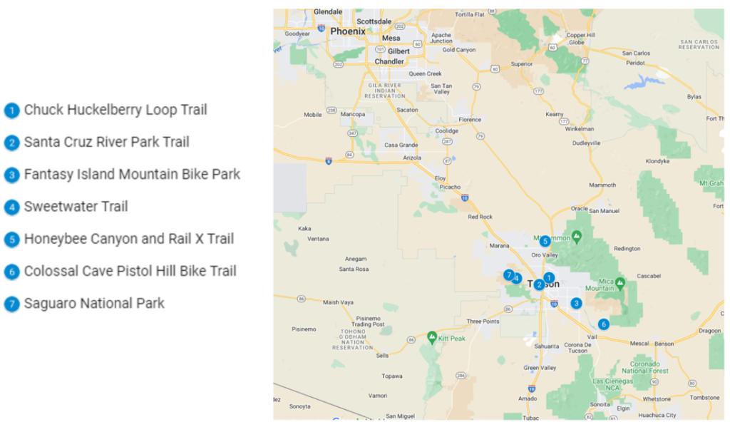
1. Chuck Huckelberry Loop Trail
The Chuck Huckelberry Loop is Tucson’s premier multi-use urban path, a 136-mile loop that weaves itself around the eastern and southeastern sides of the city of Tucson with a typical Arizona desert background. It is a fantastic asset for Tucson residents and visitors alike and has recently been designated the “best bike path in the United States”.
The “Loop,” as it is called, only attained the status of a complete loop in January 2018 but there are constant moves to expand and improve the network. It is the longest urban multi-use path in the U.S. and is an excellent way of getting around the city rather than using a motorized vehicle.
The Loop is not a mountain bike trail like some of the other popular Tucson bike trails as it is truly multiuse designed for the enjoyment of walkers, joggers, bicyclists and even horse riders. It runs through unincorporated parts of Pima County, Tucson City, South Tucson, Marana and Oro Valley connecting the Julian Wash and Harrison Greenway with Rillito, Pantano River Park, Santa Cruz River Park (see trail no 2 below) and Cañada del Oro.
The Loop is easy to use and a great way of experiencing everything that Tucson and its close surrounding area have to enjoy without worrying about where to park and getting the health benefits of cycling at the same time.
How much you ride depends on you. You can ride the whole loop or just sections of it. There are extensions to the Santa Cruz River Park trail which runs from South Tucson to Marana.
Pima County has determined that electric bikes and scooters are not permitted on the Loop, even though they are allowed elsewhere on bike trails in the county and adjacent jurisdictions. The advice for cyclists is to acknowledge that it is a multi-use path to be enjoyed and used by everyone on foot, or on a horse. Cyclists should yield to pedestrians, keep to the right of the path and pass on the left.
| Feature | Description |
| Location | East, Central and South East Tucson. Can be accessed at multiple locations around the loop. |
| Trail length | Whole loop is more than 130 miles in extent and still expanding. |
| Loop, out and back or point to point | A loop. |
| Level of difficulty | Easy/ Beginner. |
| Terrain | Two-lane asphalt bike path. |
| Grade of track | Mostly flat. |
| Average time to complete | Cycling the whole loop could take all day! Slow down, enjoy the vibes and sights and take your time. |
| Stop-off points for refreshments/water and other facilities | Many places along the Loop where you can find a restroom, water, refreshments, coffee and restaurants. |
2. Santa Cruz River Park Trail
The Santa Cruz River trail is a riverside bike trail that connects South Tucson with Marana in the North West. For much of its pathway, it follows the normally dry bed of the Santa Cruz River, which bisects the city of Tucson.
Like the Chuck Huckelberry Loop with which the Santa Cruz River Park Trail is connected, the trail is designed for pleasant, easy cycling along a mostly flat gradient with occasional uphill segments as you climb out of underpasses.
The River Trail is not just available for cyclists, despite that on any given day and especially on a weekend, bike riders are the most commonest trail users. Hikers, horse riders and runners also use the trail so you need to be aware of the polite protocol as you approach another trail user.
The whole trail is nearly 42 miles long and connects the old, historical birthplace of the city in the South with the suburbs of Midvale Park, Santa Cruz Southwest, El Camino Del Cerro and Marana.
You certainly won’t be starved or thirsty on this bike path as there are scores of restaurants and bars on the way together with other sources of refreshment. The trail passes through numerous parks and there are plenty of restrooms and water points to satisfy your relief on the way.
Tucson’s unique desert mountain surroundings are never far away and along the path at certain times of the year, thousands of wildflowers line the route.
| Feature | Description |
| Location | Along the Santa Cruz River from W Valencia Rd in the South to North Sanders Rd in the North at Marana. |
| Trail length | 41.8 miles. |
| Loop, out and back or point to point | Point to point. |
| Level of difficulty | Easy. |
| Terrain | Asphalted 2-lane bike path. |
| Grade of track | Flat ride along the river bank. |
| Average time to complete | 3 to 4 hours. |
| Stop-off points for refreshments/water or other facilities. | Plenty of restrooms, parks, water points, refreshments and other facilities along the trail. |
3. Fantasy Island Mountain Bike Park
Fantasy Island is one of Tucson’s oldest networks of bike trails. It is a true mountain bike destination close enough to the center of the city on the south side near the Davis Monthan Airforce Base.
The network of trails is ridden counterclockwise with one main loop, called Lone Cactus, and several other loops branching off. The Bunny Loop is one of the best for beginners as it is mainly flat with the occasional washout to look out for.
The reason it is called Fantasy Island is that at almost every turn there are some weird and wonderful treasures to watch out for, like old rusting bikes, discarded furniture, old cars, kids’ toys and even a cowbell you pass under at the start of the Burro Trail.
Fantasy Island is technically on State Trust Land, so you should get yourself a permit if you are going to spend much time zooming around Fantasy Island.
Fantasy Island is one of Tucson’s best-known and most popular bike trail parks as it is so close to the city and has a range of track grades. Bunny Loop is on the south side of the main loop close to the southern entrance and is quite flat and easy so a good place to do some MTB training and bring the kids as well. The northern sections of the trail network are hillier and more challenging, so better left until you gain experience. Contact the Sonoran Desert Mountain Bicyclists (SDMB) to see if they are going to organize a Saturday night ride, which can be really fun, riding in the desert under the moon!
In summer, take care if there has been any amount of rain as it can cause washouts. Also, look out for snakes amongst the cacti!
| Feature | Description |
| Location | South Central Tucson. Main Trailhead for parking at Harrison and Irvington. Bunny Loop access is on the North side of Valencia Road and Frost Drive. |
| Trail length | Bunny Loop is only 5.5 miles. |
| Loop, out and back or point to point | The whole Fantasy Island bike trail network is a counter-clockwise loop with alternative trails branching off from the main loop. |
| Level of difficulty | Easy/ Beginner: bring your kids |
| Terrain | Flat on the Bunny Loop – Northern trails are a little hillier |
| Grade of track | Flat, fast and fun on the Bunny. Northern trails technical riding needed |
| Average time to complete | Allow 40 minutes for the Bunny Loop |
| Stop-off points for refreshments/water and other facilities | A table, map, medical kit and other goodies are available at the North trailhead. There are no other facilities in Fantasy Island, but the city is close by. Use the bathroom before hitting the trail and take water and snacks with you. |
4. Sweetwater MTB Trail – Saguaro Vista Trail, Sun Circle and Black Rock Loops combined
The Sweetwater MTB Trail network is one of the most recent of the rapidly growing Tucson bike trail networks and has become very popular very quickly. It’s easy to get to from anywhere in the city and the variety of trail grades and levels of difficulty mean there is something for everyone from beginners to MTB veterans. The three trails highlighted here are the easiest of the Sweetwater trails, mostly flat with some hilly sections. The whole network is very well signposted but like many MTB trail networks, the more you ride any of the trails the better you can navigate your way around.
The scenery is great as the trails wind in and around giant Saguaro cacti in the classic Arizona desert landscape close to the surrounding Sweetwater Preserve, under the management of Pima County’s National Parks, Resources and Recreation. When you are on the trails, it’s hard to imagine the whole area is surrounded on all sides by residential areas. This means that at least it’s virtually impossible to get lost. You may see hikers and even horse riders as well as MTB riders so keep a sharp eye out, especially on downhill sections.
When you feel you are ready for something more challenging, it’s easy to transfer over to some of the hillier sections that switch back up and down with some washouts, especially if it has rained heavily recently. The Lost Arrow Trail is the hilliest trail in Sweetwater’s network and will certainly get your cardio pumping. Over at the Red Canyon Trail, there are rocky sections which are quite challenging without more experience.
| Feature | Description |
| Location | West side of Tucson. Trailhead is at end of Tortolita Road. |
| Trail length | About 4 miles for the 3 combined trail sections. |
| Loop, out and back or point to point | Saguaro Vista is a one-way trail. Black Rock and Sun Circle are both loops. |
| Level of difficulty | Easy / Beginner. Other parts of the Sweetwater Trail network are more challenging. |
| Terrain | Hard surface, some rocky or sandy patches with one section of shale. |
| Grade of trail | Mostly flat with a small hilly section on the Black Rock Loop. |
| Average time to complete | Allow up to 40 minutes. |
| Stop-off points for refreshments/water and other facilities | No facilities in the trail area. Surrounded by suburbia so take water and snacks with you. |
5. Honeybee Canyon and Rail X Trails
Honeybee Canyon and Rail X are combined bike trails and hiking paths. They are great for beginner MTB riders and are both located in a very pretty area reasonably close to the city, but which is actually part of the Tortolita State Park with its wider Pima County bike trails network. This area is under the management of Pima County’s National Resources, Parks and Recreation.
The Rail X and Honeybee Canyon trails are relatively flat with terrain a mixture of jeep trails, asphalt, dirt roads and single bike tracks.
Apart from navigating your way around the trails, there are opportunities to see petroglyphs, although you may have to get off your bike and hike down to see these. The easiest petroglyphs to see are found on your left as you hike along a small trail heading north out of Honeybee Canyon.
The trails also cross some of Rancho Vistoso, so you may come across cattle on the open range and even a windmill or two. This is a classic, attractive desert country.
The trail network is not so well marked but is on mostly easy firm surfaces, so it is quite suitable for hardtail mountain bikes, so if you don’t have full suspension, relax as you don’t really need it here. Use an MTB mobile app or follow the GPX files you can download from the MTB Project website. At one point, up near the windmill, you will go through a gate. Close it if it is shut when you get to it.
| Feature | Description |
| Location | West of Tucson City near Tortolita Park. Parking area along Rancho Vistoso Blvd. |
| Trail length | Up to 12 miles in total in Rail X and Honeybee sections, but many more miles are possible in the adjacent Tortolita Park. |
| Loop, out and back or point to point | One large loop. |
| Level of difficulty | Beginner / easy but some sections need more skill. |
| Terrain | A mixture of asphalt, dirt, 4 wheel drive track, generally firm surface |
| Grade of track | Some hilly sections with maximum 500 feet of elevation. |
| Average time to complete | Allow up to an hour. |
| Stop-off points for refreshments/water and other facilities | No water or other facilities like restrooms. Visit the bathroom before you ride here and bring water and snacks. |
6. Colossal Cave Pistol Hill Bike Trail
This bike trail is one of the most popular in Tucson for good reason. It is not an MTB trail and the whole length is on asphalt. A well-marked bike lane/shoulder is available. You can combine this trail with the Loop in nearby Saguaro National Park or ride all the way there and back from Tucson. You need to look out for motorized traffic as drivers may be looking at the views and not at you when passing!
The main challenge is the relatively steep hills. The elevation gain is more than 1,600 feet so this puts the trail into the intermediate or moderate category. If you go through the main gate when you reach Colossal Cave, there is an admission fee, but once through you can cycle onto Pistol Hill on a less well-maintained road. Once you get to the top of Pistol Hill, there is an awesome view across Tucson City.
There are also more challenging MTB trails available on one section of the Arizona Trail as it winds its way across Arizona through the Colossal Cave Park and Pistol Hill area. These trails are additional to the main trail on the road through Colossal Cave to Pistol Hill. The Arizona National Scenic Trail is the longest trail in Arizona but is multi-use and you will encounter hikers and horse riders apart from MTB riders.
The Arizona Trail spans 800 miles from the Mexican border in the south to the Utah border in the north. Not all of it is accessible to bike riders as some of the wilderness sections are prohibited to cyclists. The trail is point-to-point, so you need good backup from friends or family and organize a way to get back.
| Feature | Description |
| Location | Southeast of Tucson on the western edge of Saguaro National park. |
| Trail length | 21 to 40 miles. |
| Loop, out and back or point to point | Straight section, then a shorter loop with some alternative deviations. |
| Level of difficulty | Moderate. |
| Terrain | Mountain road with a marked bike lane. Watch out for motorized traffic. |
| Grade of track | Elevation gain on the whole trail system over 1,600 feet. |
| Average time to complete | Allow up to 2 to 3 hours but varies depending on how much is ridden. |
| Stop-off points for refreshments/water or other facilities. | No facilities on this trail except at Colossal Cave where there are refreshments. Need to bring water in summer. |
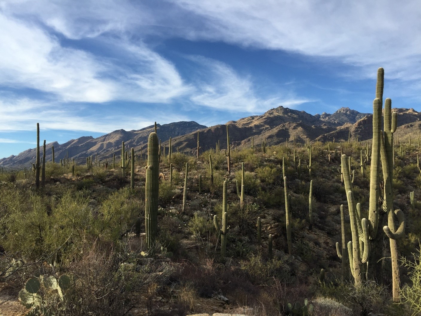
7. Saguaro National Park
The Saguaro National Park to the east of Tucson City is a spectacular mountain preserve with multiple opportunities for bike riders, hikers, horse riders and motorized visitors. There is one long, steep, spectacular bike trail in Saguaro National Park called “The Loop” by Tucson bike riders. It’s not a mountain bike trail as it is all on asphalt on the National Park road system, so you can take road bikes as well as MTB or gravel bikes.
The bike path can be ridden all the way from the city to add a few more miles. The main loop trail is in very attractive rolling mountain scenery in the Rincon Mountains. Saguaro cacti are common as they are elsewhere in the Sonoran Desert, but there is wildlife to encounter too, especially in the early mornings and evenings. Look out for white-tailed and mule deer, rabbits, coyotes, javelinas, gray foxes and there are even cougars, but these are shy creatures, so you are unlikely to come across one! Motorized vehicles, although not busy on weekdays are a bigger threat than wildlife.
The main loop in Saguaro National Park is rated as moderate because of the amount of climbing involved. One of the trickier sections is at the start of the loop where there is a sharp turn after a steep, downhill section.
Saguaro National Park was originally preserved as Saguaro National Monument back in 1961 and then a full national park in 1994. Hiking trails and campsites were developed, but it wasn’t until bike riding and trail riding became popular in Tucson that the Loop was seen as a great bike trail.
There is a national park entry fee to be paid to ride into Saguaro National Park. A 7-day access pass can also be purchased or an annual pass for you and 3 other riders if you live in Tucson.
| Feature | Description |
| Location | South East of Tucson City in Saguaro National Park. |
| Trail length | Up to 21 miles in length for a full loop. |
| Loop, out and back or point to point | Mostly a long loop. |
| Level of difficulty | Moderate. |
| Terrain | Asphalt road. |
| Grade of track | Rolling hills with possible elevation gain of up to 650 feet. |
| Average time to complete | Allow 1 to 1 and a half hours. |
| Stop-off points for refreshments/water or other facilities. | The visitor’s center at the start of the ride has restrooms and water fountains. |